IMAGES TAKEN NEAR TO
Edridge Place, CORSHAM, SN13 9UN
Introduction
This page details the photographs taken nearby to Edridge Place, SN13 9UN by members of the Geograph project.
The Geograph project started in 2005 with the aim of publishing, organising and preserving representative images for every square kilometre of Great Britain, Ireland and the Isle of Man.

There are currently over 7.5m images from over14,400 individuals and you can help contribute to the project by visiting https://www.geograph.org.uk
Image Map
Images are licensed for reuse under creativecommons.org/licenses/by-sa/2.0
Notes
- Clicking on the map will re-center to the selected point.
- The higher the marker number, the further away the image location is from the centre of the postcode.
Image Listing (4 Images Found)
Images are licensed for reuse under creativecommons.org/licenses/by-sa/2.0
Image
Details
Distance
1
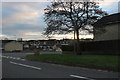
Valley Road looking towards West Park Road
Most of the houses in Corsham are sandstone coloured.
Image: © David Howard
Taken: 4 Jan 2020
0.12 miles

3
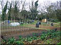
Allotments, Corsham
Use of land as allotment gardens goes back to before the reign of Elizabeth I, but it was during the World Wars that allotments became really popular with city-dwellers and country people alike.
Fresh fruit and vegetables were in short supply, so driven by the government Dig for Victory campaign, townfolk dug up public parks, playing fields and village greens to grow their own.
Image: © Maigheach-gheal
Taken: 11 Apr 2010
0.22 miles
4
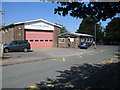
Corsham Fire Station
A view looking to the northeast towards the Fire Station at Corsham.
Image: © Phil Williams
Taken: 27 Jul 2006
0.23 miles