IMAGES TAKEN NEAR TO
Wadswick Lane, CORSHAM, SN13 9TA
Introduction
This page details the photographs taken nearby to Wadswick Lane, SN13 9TA by members of the Geograph project.
The Geograph project started in 2005 with the aim of publishing, organising and preserving representative images for every square kilometre of Great Britain, Ireland and the Isle of Man.

There are currently over 7.5m images from over14,400 individuals and you can help contribute to the project by visiting https://www.geograph.org.uk
Image Map
Images are licensed for reuse under creativecommons.org/licenses/by-sa/2.0
Notes
- Clicking on the map will re-center to the selected point.
- The higher the marker number, the further away the image location is from the centre of the postcode.
Image Listing (4 Images Found)
Images are licensed for reuse under creativecommons.org/licenses/by-sa/2.0
Image
Details
Distance
1
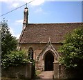
St. Philip and St. James', Neston
I first saw this church forty years ago (March 1969) as a twelve year old schoolboy, and so began a lifelong interest in church architecture.
Image: © Kevin Farmer
Taken: 1 Jun 2004
0.04 miles
2
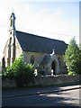
St. Philip and St. James, Neston
A view looking to the northwest towards the church of St. Philip and St. James at Neston.
Image: © Phil Williams
Taken: 27 Jul 2006
0.05 miles
3
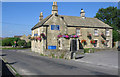
Church Rise
A view looking north along Church Rise towards the Neston Country Inn public house.
Image: © Phil Williams
Taken: 27 Jul 2006
0.19 miles
4
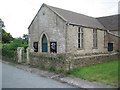
Neston Gospel Hall
A view looking southeast across Chapel Lane towards Neston Gospel Hall.
Image: © Phil Williams
Taken: 31 Jul 2006
0.19 miles