IMAGES TAKEN NEAR TO
Spackman Lane, CORSHAM, SN13 9LD
Introduction
This page details the photographs taken nearby to Spackman Lane, SN13 9LD by members of the Geograph project.
The Geograph project started in 2005 with the aim of publishing, organising and preserving representative images for every square kilometre of Great Britain, Ireland and the Isle of Man.

There are currently over 7.5m images from over14,400 individuals and you can help contribute to the project by visiting https://www.geograph.org.uk
Image Map (Loading...)


Getting Data...Please wait
Leaflet Map data © OpenStreetMap
Images are licensed for reuse under creativecommons.org/licenses/by-sa/2.0
Notes
- Clicking on the map will re-center to the selected point.
- The higher the marker number, the further away the image location is from the centre of the postcode.
Image Listing (5 Images Found)
Images are licensed for reuse under creativecommons.org/licenses/by-sa/2.0
Image
Details
Distance
2
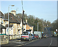
2008 : The new road to Corsham
The old road turned sharp right on the other side of the railway bridge at the bottom of the hill and went into Corsham village. Now it takes you straight through to the A4 near Pickwick.
Image: © Maurice Pullin
Taken: 25 Feb 2008
0.23 miles

4
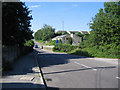
Valley Road
A view looking north along Valley Road towards the single track bridge over the main London-Bristol railway line.
Image: © Phil Williams
Taken: 27 Jul 2006
0.25 miles
5
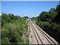
Rails to the capital
A view looking east along the main Bristol-London railway line from the single track bridge on Valley Road. The bridge in the far distance is carrying the B3353 over the railway.
Image: © Phil Williams
Taken: 27 Jul 2006
0.25 miles