IMAGES TAKEN NEAR TO
Allen Road, CORSHAM, SN13 9LA
Introduction
This page details the photographs taken nearby to Allen Road, SN13 9LA by members of the Geograph project.
The Geograph project started in 2005 with the aim of publishing, organising and preserving representative images for every square kilometre of Great Britain, Ireland and the Isle of Man.

There are currently over 7.5m images from over14,400 individuals and you can help contribute to the project by visiting https://www.geograph.org.uk
Image Map
Images are licensed for reuse under creativecommons.org/licenses/by-sa/2.0
Notes
- Clicking on the map will re-center to the selected point.
- The higher the marker number, the further away the image location is from the centre of the postcode.
Image Listing (2 Images Found)
Images are licensed for reuse under creativecommons.org/licenses/by-sa/2.0
Image
Details
Distance
1
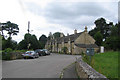
Hudswell
A view looking southwest along St. Barbaras Lane towards Hudswell Lane (right).
Image: © Phil Williams
Taken: 31 Jul 2006
0.14 miles
2

Old Milestone by the B3109, Bradford Road, Box parish
Bath limestone with iron plate by the B3109, in parish of Box (North Wiltshire District), roadside, North side of the road.
Plate lost since 2000, stone block still set in wall.
Inscription reads:-
99
Miles from
Hyde Park
Corner
8
Miles from
BATH
Milestone Society National ID: WI_LB_BABHc08
Image: © Milestone Society
Taken: Unknown
0.20 miles