IMAGES TAKEN NEAR TO
Westwells Road, CORSHAM, SN13 9ET
Introduction
This page details the photographs taken nearby to Westwells Road, SN13 9ET by members of the Geograph project.
The Geograph project started in 2005 with the aim of publishing, organising and preserving representative images for every square kilometre of Great Britain, Ireland and the Isle of Man.

There are currently over 7.5m images from over14,400 individuals and you can help contribute to the project by visiting https://www.geograph.org.uk
Image Map
Images are licensed for reuse under creativecommons.org/licenses/by-sa/2.0
Notes
- Clicking on the map will re-center to the selected point.
- The higher the marker number, the further away the image location is from the centre of the postcode.
Image Listing (5 Images Found)
Images are licensed for reuse under creativecommons.org/licenses/by-sa/2.0
Image
Details
Distance
1
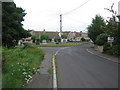
Westwells
A view looking north to the junction of Westwells Road (left).
Image: © Phil Williams
Taken: 31 Jul 2006
0.07 miles
2
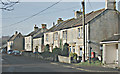
2008 : Old Westwells near Corsham
A rank of older housing at Westwells.
Image: © Maurice Pullin
Taken: 25 Feb 2008
0.11 miles
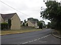
4
Moor Park Housing at Moor Green, West Wells
Sympathetic additions to an ancient hamlet.
Image: © Ben Croft
Taken: 14 May 2005
0.20 miles
5
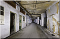
Spring Quarry
The Bath stone quarry was converted into a WW2 shadow factory that manufactured aircraft engines and gun parts. After the war it was used as a Royal Navy stores and one section known as Site 3 became the Central Government War Headquarters. Although much of the underground space remains empty, a section of the western side of the quarry now forms part of the Corsham Media Park.
Image: © Noel Jenkins
Taken: Unknown
0.22 miles