IMAGES TAKEN NEAR TO
Old Jockey, CORSHAM, SN13 8JQ
Introduction
This page details the photographs taken nearby to Old Jockey, SN13 8JQ by members of the Geograph project.
The Geograph project started in 2005 with the aim of publishing, organising and preserving representative images for every square kilometre of Great Britain, Ireland and the Isle of Man.

There are currently over 7.5m images from over14,400 individuals and you can help contribute to the project by visiting https://www.geograph.org.uk
Image Map (Loading...)


Getting Data...Please wait
Leaflet Map data © OpenStreetMap
Images are licensed for reuse under creativecommons.org/licenses/by-sa/2.0
Notes
- Clicking on the map will re-center to the selected point.
- The higher the marker number, the further away the image location is from the centre of the postcode.
Image Listing (7 Images Found)
Images are licensed for reuse under creativecommons.org/licenses/by-sa/2.0
Image
Details
Distance
1
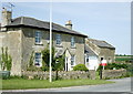
2008 : Cross Roads Farm
At the "cross" roads formed by the A365 Box to Atworth, the B3109 Corsham to Bradford on Avon and a minor road to Kingsdown.
Image: © Maurice Pullin
Taken: 13 May 2008
0.01 miles
2
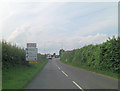
Five-ways Junction
Why five-ways? Because the B3109 crosses the A365 and an additional minor road from Kingsdown makes up the quintet.
Image: © Stuart Logan
Taken: 13 Jul 2011
0.03 miles
3

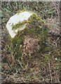
Old Milestone by the A365, Devizes Road, Box Fiveways
Metal plate (stolen after 2009) attached to stone post by the A365, in parish of BOX (NORTH WILTSHIRE District), Devizes Road. At Fiveways Crossroads junction with Kingsdown Road, on wide grass verge back from apex of junction, on South side of road. Bath hands iron plate (terminus), erected by the Bath turnpike trust in the 19th century.
Inscription once read:-
THE
BATH ROADS
{hand->}
TO THE
GUILDHALL
BATH
7
Grade II listed.
List Entry Number: 1285258 https://historicengland.org.uk/listing/the-list/list-entry/1285258
Milestone Society National ID: WI_LB_BABH07x.
Image: © A Rosevear
Taken: 14 Aug 2003
0.03 miles
4
Old Milestone by the A365, Devizes Road, Box
Bath limestone with iron plate by the A365, in parish of Box (North Wiltshire District), Devizes Road; 100m South East of Hatt Lane junction; down the hill from Five Ways, in front of a deep hedge at back of grass verge.
Inscription reads:-
7
Miles
To
BATH
Carved benchmark is recorded.
Grade II listed.
List Entry Number: 1022768 https://historicengland.org.uk/listing/the-list/list-entry/1022768?section=official-list-entry
Milestone Society National ID: WI_lb_badz07
Image: © Milestone Society
Taken: Unknown
0.14 miles
5
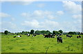
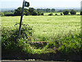
2008 : Herd out to pasture
Seen from a layby near Cross Roads Farm on the B3109.
The herd is probably from Wormwood Farm which is seen beyond.
Image: © Maurice Pullin
Taken: 7 Jun 2008
0.24 miles
6
Stone Stile, Lower Wadswick
On Wiltshire footpath BOX58, looking North to the A365. The view from the road is Image
Image: © Mr Red
Taken: 27 May 2022
0.25 miles
7
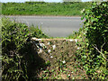
Stone Stile, Lower Wadswick
On Wiltshire footpath BOX58, looking South from the A365. The view looking to the road is Image
Image: © Mr Red
Taken: 27 May 2022
0.25 miles