IMAGES TAKEN NEAR TO
Box Hill, CORSHAM, SN13 8HR
Introduction
This page details the photographs taken nearby to SN13 8HR by members of the Geograph project.
The Geograph project started in 2005 with the aim of publishing, organising and preserving representative images for every square kilometre of Great Britain, Ireland and the Isle of Man.

There are currently over 7.5m images from over14,400 individuals and you can help contribute to the project by visiting https://www.geograph.org.uk
Image Map
Images are licensed for reuse under creativecommons.org/licenses/by-sa/2.0
Notes
- Clicking on the map will re-center to the selected point.
- The higher the marker number, the further away the image location is from the centre of the postcode.
Image Listing (12 Images Found)
Images are licensed for reuse under creativecommons.org/licenses/by-sa/2.0
Image
Details
Distance
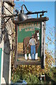
1
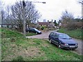
Box Common
A view from Box Common towards the Quarrymans Arms.
Image: © Derek Hawkins
Taken: 1 Feb 2007
0.05 miles
2
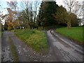
Forking tracks
Left to Grove Farm, right to Box Hill.
Image: © Jonathan Billinger
Taken: 19 Nov 2013
0.06 miles
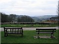
4
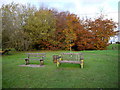
Benches on Box Hill Common
The view west over the Box valley is behind the camera.
Image: © Jonathan Billinger
Taken: 19 Nov 2013
0.09 miles

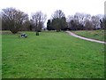
7
View from Box Common.
This is the view from the two seats at the top of Quarry Hill at the edge of Box Common. Here you look down over Box and down the By valley towards Bath.
Image: © Derek Hawkins
Taken: 1 Feb 2007
0.18 miles
8
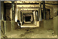
Spring Mine Box Hill Wilts
MOD modified section
Image: © Nick Chipchase
Taken: 1 Mar 2009
0.18 miles
9
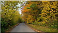
Quarry Hill, Box
Ascending Box Hill from Box village.
Image: © Jonathan Billinger
Taken: 19 Nov 2013
0.20 miles
10
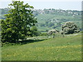
2008 : Meadow east of Box
The Box Tunnel is immediately beneath the fence and gate on the other side of this field.
Colerne with its church is on the skyline.
Image: © Maurice Pullin
Taken: 13 May 2008
0.20 miles