IMAGES TAKEN NEAR TO
The Brownings, CORSHAM, SN13 8HP
Introduction
This page details the photographs taken nearby to The Brownings, SN13 8HP by members of the Geograph project.
The Geograph project started in 2005 with the aim of publishing, organising and preserving representative images for every square kilometre of Great Britain, Ireland and the Isle of Man.

There are currently over 7.5m images from over14,400 individuals and you can help contribute to the project by visiting https://www.geograph.org.uk
Image Map
Images are licensed for reuse under creativecommons.org/licenses/by-sa/2.0
Notes
- Clicking on the map will re-center to the selected point.
- The higher the marker number, the further away the image location is from the centre of the postcode.
Image Listing (46 Images Found)
Images are licensed for reuse under creativecommons.org/licenses/by-sa/2.0
Image
Details
Distance
1
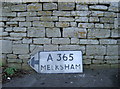
It's that way
A pre-Worboys sign has been left on the ground for some reason. Maybe it will be resurrected, maybe it will be replaced with a modern version.
Image: © Neil Owen
Taken: 16 Jan 2012
0.05 miles
2
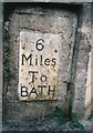
Old Milestone by the A365, Devizes Road, Box
Metal plate attached to stone post by the A365, in parish of Box (North Wiltshire District), Devizes Road; in garden wall of "Lyndale", opposite The Ley, set in stone retaining wall beside footpath and close to driveway, on South side of road. Erected by the Lacock, Blue Vein (Corsham) turnpike trust in the 19th century.
Inscription reads:-
6
Miles
To
BATH
Grade II listed.
List Entry Number: 1022767 https://historicengland.org.uk/listing/the-list/list-entry/1022767
Milestone Society National ID: WI_LB_BADZ06
Image: © A Rosevear
Taken: 2 Sep 2003
0.06 miles
3
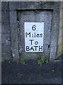
Milestone in Box
Located on the Devizes Road, opposite the Leys. Right beside it is a cut benchmark - see http://www.bench-marks.org.uk/bm41393 for the entry in the Benchmark Database.
Image: © Neil Owen
Taken: 16 Jan 2012
0.06 miles
4
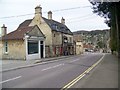
The Queen's Head, Box
The pub is to be found on the north side of the High Street. For a view of the sign Image
Image: © Maigheach-gheal
Taken: 11 Apr 2010
0.07 miles
5
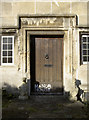
This must be it
The door has a handy description on it for those who aren't too sure where they are.
Image: © Neil Owen
Taken: 16 Jan 2012
0.07 miles
6
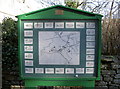
Handy map
Find where you are and where you want to go in Box. Luckily it's not a big place.
Image: © Neil Owen
Taken: 16 Jan 2012
0.07 miles
7
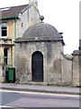
Blind house, Box
The blind house or lock-up is constructed of ashlar and was built in the early 18th century.
Image: © Maigheach-gheal
Taken: 11 Apr 2010
0.07 miles
8
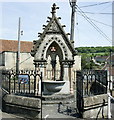
2008 : Public drinking fountain, Box
A typical piece of Victoriana, note the railings. There is a horse trough built into the other side and an inscription Image]
Image: © Maurice Pullin
Taken: 13 May 2008
0.08 miles
9
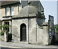
2008 : The Blind House, Box
A small stone lockup from former times where miscreants could be kept overnight until they could be dealt with by the local court, or until they had sobered up.
There is a similar building in Image]
Image: © Maurice Pullin
Taken: 13 May 2008
0.08 miles
10
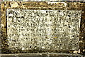
2008 : Inscription on Drinking Fountain
This inscription appears on the wall behind Image]
Can anyone work out the date? No prizes.
This photograph has been digitally enhanced to improve legibility.
Image: © Maurice Pullin
Taken: 13 May 2008
0.08 miles