IMAGES TAKEN NEAR TO
Box Hill, CORSHAM, SN13 8EU
Introduction
This page details the photographs taken nearby to SN13 8EU by members of the Geograph project.
The Geograph project started in 2005 with the aim of publishing, organising and preserving representative images for every square kilometre of Great Britain, Ireland and the Isle of Man.

There are currently over 7.5m images from over14,400 individuals and you can help contribute to the project by visiting https://www.geograph.org.uk
Image Map (Loading...)


Getting Data...Please wait
Leaflet Map data © OpenStreetMap
Images are licensed for reuse under creativecommons.org/licenses/by-sa/2.0
Notes
- Clicking on the map will re-center to the selected point.
- The higher the marker number, the further away the image location is from the centre of the postcode.
Image Listing (8 Images Found)
Images are licensed for reuse under creativecommons.org/licenses/by-sa/2.0
Image
Details
Distance

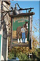
3
Box Common
A view from Box Common towards the Quarrymans Arms.
Image: © Derek Hawkins
Taken: 1 Feb 2007
0.12 miles
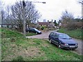
4
2008 : Junction of Beech Road and Hedgesparrow Lane
At this point Beech Road, which has been almost level, plunges down a steep hill to meet the A4 about 100 yards further on.
Hedgesparrow Lane takes a shorter route and a steeper hill to do the same.
At Box Hill.
Image: © Maurice Pullin
Taken: 25 Feb 2008
0.15 miles
5
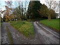
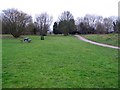
Forking tracks
Left to Grove Farm, right to Box Hill.
Image: © Jonathan Billinger
Taken: 19 Nov 2013
0.18 miles
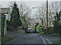
7
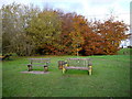
Benches on Box Hill Common
The view west over the Box valley is behind the camera.
Image: © Jonathan Billinger
Taken: 19 Nov 2013
0.19 miles
8
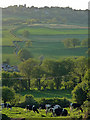
Farmland, Box Hill
Beyond the cows a minor road winds its way up the hill towards Colerne, whose church tower can be made out on the skyline (see Image]).
.
Image: © Stephen Richards
Taken: 25 May 2012
0.21 miles