IMAGES TAKEN NEAR TO
Fair View, CORSHAM, SN13 8DX
Introduction
This page details the photographs taken nearby to Fair View, SN13 8DX by members of the Geograph project.
The Geograph project started in 2005 with the aim of publishing, organising and preserving representative images for every square kilometre of Great Britain, Ireland and the Isle of Man.

There are currently over 7.5m images from over14,400 individuals and you can help contribute to the project by visiting https://www.geograph.org.uk
Image Map
Images are licensed for reuse under creativecommons.org/licenses/by-sa/2.0
Notes
- Clicking on the map will re-center to the selected point.
- The higher the marker number, the further away the image location is from the centre of the postcode.
Image Listing (45 Images Found)
Images are licensed for reuse under creativecommons.org/licenses/by-sa/2.0
Image
Details
Distance
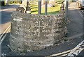
1
High road, low road
The junction of the High Street and the Devizes Road is acute. Right on the apex is this informative direction sign, way before Worboys style signs came along. Of course, there are lots of traffic lights and signs now.
Image: © Neil Owen
Taken: 16 Jan 2012
0.04 miles
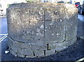
2
Old Guide Stone by the A4, High Street, Box
Guide Stone by the A4, in parish of Box (North Wiltshire District), High Street, by traffic lights at junction with Devizes Road, opposite The Bear at Box PH, forms the apex of the road junction as a stone barrier wall.
Surveyed
Milestone Society National ID: WI_LB_BACN06A100a
Image: © Milestone Society
Taken: Unknown
0.04 miles
3
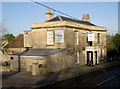
The Bear, Box High Street
Open for tasty meals and a drink.
Image: © Neil Owen
Taken: 16 Jan 2012
0.06 miles
4
Tomb, St Thomas ? Becket churchyard, Box
Another view of the unusual tombstone seen here http://www.geograph.org.uk/photo/1443538
Image: © Brian Robert Marshall
Taken: 14 Aug 2009
0.07 miles
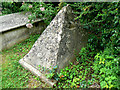
5
Tombs, St Thomas ? Becket churchyard, Box
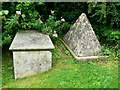
The last burial took place here in 1896 following the opening of the town cemetery nearly fifty years earlier http://www.geograph.org.uk/photo/1443510 The tomb on the right has an unusual pyramidal structure above it. Word has it that the widow of the man buried there planned to celebrate his passing by dancing on his grave. To forestall that eventuality someone, a relative perhaps, erected the pyramid. There are no inscriptions on the grave, or none that are legible, so it is not possible to ascertain any more than this.
Image: © Brian Robert Marshall
Taken: 14 Aug 2009
0.07 miles
6
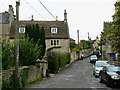
Church Lane, Box, Wiltshire
The lane leads up from the church of St Thomas à Becket to the A4 old coaching road.
Image: © Brian Robert Marshall
Taken: 14 Aug 2009
0.07 miles
7
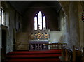
At the Altar
The altar of St Thomas à Becket church.
Image: © Neil Owen
Taken: 29 Feb 2012
0.08 miles
8
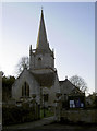
St Thomas a Becket church, Box
A church was first established here in around 1200, but the current structure is almost entirely of a later date. The spire is a prominent landmark along the main road.
Image: © Neil Owen
Taken: 16 Jan 2012
0.08 miles
9
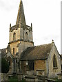
St Thomas a Becket church, Box, from SE
Parish church of Box, Wiltshire. Grade I listed.
https://historicengland.org.uk/listing/the-list/list-entry/1180500
Image: © Steve Roberts
Taken: 11 Feb 2022
0.08 miles
10
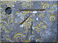
1GL Boltmark on Box church
A lovely old benchmark in the north face of Box's Thomas à Becket church. The lichen seem to be making camouflage for it. See http://www.bench-marks.org.uk/bm19692 for the entry in the Benchmark Database, and Image] for a location shot.
Image: © Neil Owen
Taken: 29 Feb 2012
0.08 miles