IMAGES TAKEN NEAR TO
The Orangery, Academy Drive, CORSHAM, SN13 0SF
Introduction
This page details the photographs taken nearby to The Orangery, Academy Drive, SN13 0SF by members of the Geograph project.
The Geograph project started in 2005 with the aim of publishing, organising and preserving representative images for every square kilometre of Great Britain, Ireland and the Isle of Man.

There are currently over 7.5m images from over14,400 individuals and you can help contribute to the project by visiting https://www.geograph.org.uk
Image Map (Loading...)


Getting Data...Please wait
Leaflet Map data © OpenStreetMap
Images are licensed for reuse under creativecommons.org/licenses/by-sa/2.0
Notes
- Clicking on the map will re-center to the selected point.
- The higher the marker number, the further away the image location is from the centre of the postcode.
Image Listing (10 Images Found)
Images are licensed for reuse under creativecommons.org/licenses/by-sa/2.0
Image
Details
Distance
1
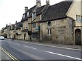
The Two Pigs, Corsham
The pub stands beside the A4 in an area of Corsham known as Pickwick.
Image: © Maigheach-gheal
Taken: 11 Apr 2010
0.12 miles
2
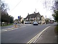
The Hare and Hounds, Corsham
The Hare and Hounds is beside the A4, which goes through an area of Corsham called Pickwick.
Image: © Maigheach-gheal
Taken: 11 Apr 2010
0.13 miles
3
The Hare and Hounds, Corsham
The Hare and Hounds was once the home of Moses Pickwick who gave his name to this area of the town and also ran horse-drawn carriages from Bath to London. It is recorded that Charles Dickens visited the pub and borrowed Mr Pickwick's surname for the title of his famous book.
Image: © Stuart Logan
Taken: 13 Jul 2011
0.14 miles
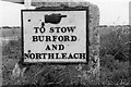
4
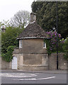
Old Toll House by the A4, Corsham
Pickwick Toll House by the A4, in parish of Corsham (North Wiltshire District), roundhouse (summerhouse) in garden wall of No. 51 Bath Road, Pickwick, opposite Park Lane, SN13.
Grade II listed.
List Entry Number: 1022086 https://historicengland.org.uk/listing/the-list/list-entry/1022086
Surveyed
Milestone Society National ID: WI.COR
Image: © Alan Rosevear
Taken: Unknown
0.17 miles
5
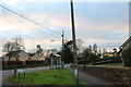
Dickens Avenue at the junction of Pickwick Road
There is a theme developing, I also did Oliver Avenue.
Image: © David Howard
Taken: 4 Jan 2020
0.18 miles
7
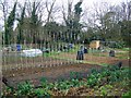
Allotments, Corsham
Use of land as allotment gardens goes back to before the reign of Elizabeth I, but it was during the World Wars that allotments became really popular with city-dwellers and country people alike.
Fresh fruit and vegetables were in short supply, so driven by the government Dig for Victory campaign, townfolk dug up public parks, playing fields and village greens to grow their own.
Image: © Maigheach-gheal
Taken: 11 Apr 2010
0.19 miles
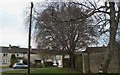
8
Old Milestone
by the B3109, in parish of (North Wiltshire District), roadside, by the road.
Lost since 2000.
Milestone Society National ID: WI_CPML07
Image: © Milestone Society
Taken: Unknown
0.19 miles
9
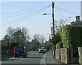
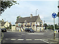
2010 : B3353 Pickwick Road, Corsham looking west
Toward the junction with the A4.
A local bus heads into the village centre.
Image: © Maurice Pullin
Taken: 2 Mar 2010
0.20 miles
10
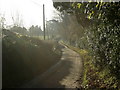
2008 : Middlewick Lane at Middlewick
You could be here all morning waiting for some interest and get nothing if you missed the postman.
They have a website! http://www.yourlocalweb.co.uk/wiltshire/middlewick/
Image: © Maurice Pullin
Taken: 1 Dec 2008
0.23 miles