IMAGES TAKEN NEAR TO
Priory Business Park, Bradford Road, CORSHAM, SN13 0RB
Introduction
This page details the photographs taken nearby to Priory Business Park, Bradford Road, SN13 0RB by members of the Geograph project.
The Geograph project started in 2005 with the aim of publishing, organising and preserving representative images for every square kilometre of Great Britain, Ireland and the Isle of Man.

There are currently over 7.5m images from over14,400 individuals and you can help contribute to the project by visiting https://www.geograph.org.uk
Image Map (Loading...)


Getting Data...Please wait
Leaflet Map data © OpenStreetMap
Images are licensed for reuse under creativecommons.org/licenses/by-sa/2.0
Notes
- Clicking on the map will re-center to the selected point.
- The higher the marker number, the further away the image location is from the centre of the postcode.
Image Listing (11 Images Found)
Images are licensed for reuse under creativecommons.org/licenses/by-sa/2.0
Image
Details
Distance
1
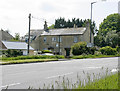
2009 : A row of cottages on the A4
With home improvements.
Regular services to Bath, Bradford on Avon and Chippenham from here. Can't wait to get my bus pass.
Image: © Maurice Pullin
Taken: 10 May 2009
0.05 miles
2
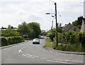
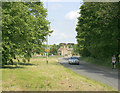
2009 : B3109 near Corsham
The car approaching on Bradford Road is about to join the A4.
Rudloe is ahead then Bradford on Avon.
Image: © Maurice Pullin
Taken: 10 May 2009
0.06 miles
3
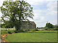
2009 : Cottages seen from the A4
Near the junction with the B3109.
The lane in front of the cottages goes to Upper Pickwick and Pickwick Lodge Farm.
Image: © Maurice Pullin
Taken: 10 May 2009
0.07 miles
4
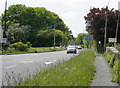
2009 : A4 looking west near Corsham
Corsham is just behind, Box is to come then Bath.
The "in" road from the B3109 is to the left. The sign on the extreme right advertises Bed and Breakfast at Pickwick Lodge Farm.
Image: © Maurice Pullin
Taken: 10 May 2009
0.08 miles
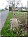
5
Milestone & Benchmark, A4, Copenacre
Bath Rd, 8 miles from Bath. South side of the road opposite modern houses.
To / Bath
Milestone Society National ID: WI_LB_BACN08
Image: © Mr Red
Taken: 23 May 2019
0.12 miles
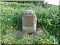
6
Milestone, Copenacre
Milestone beside the A4.
Milestones did not come into general use until the Turnpike Act of 1766 made them compulsory on turnpike roads, these roads were built by private enterprise under licence from the Government and maintained by tolls on those who used them. Before this Act milestones were put up occasionally, often as charitable acts and commemorations. Many Turnpike Act stones still exist. They are usually 2-3 ft high, with the initial letter or abbreviation of the nearest market town show on two faces, and the distance from it.
Worn bench mark on side http://www.bench-marks.org.uk/bm33843
Image: © Maigheach-gheal
Taken: 11 Apr 2010
0.13 miles
7
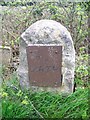
Milestone, Copenacre
The early 19th milestone has a rusty cast iron plate which no longer gives the distance to Bath. For a wider view Image and there is a worn bench mark on it http://www.bench-marks.org.uk/bm33843
Milestones are the original roadside heritage features with many dating back hundreds of years and these historic items are under threat from highway developments.
Image: © Maigheach-gheal
Taken: 11 Apr 2010
0.13 miles
8
2009 : B3109 leaving the A4 near Corsham
A lone car and a hiker head toward Bradford on Avon.
Image: © Maurice Pullin
Taken: 10 May 2009
0.19 miles
9

Copenacre
Copenacre Quarry was converted into a Naval Stores Depot (part of Spring Quarry Naval Stores Depot) and was in use from the 1940's to the mid 1990's. Here we see a telephone box and a Stores Manager's office in the background. It has now become a dumping ground for the adjoining Hartham Quarry.
Image: © Derek Hawkins
Taken: 15 Jan 1996
0.21 miles
10
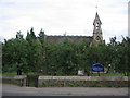
St. Patricks, Corsham
A view looking south across the A4 towards St. Patricks R.C Church.
Image: © Phil Williams
Taken: 31 Jul 2006
0.24 miles