IMAGES TAKEN NEAR TO
Leylands Road, CORSHAM, SN13 0NL
Introduction
This page details the photographs taken nearby to Leylands Road, SN13 0NL by members of the Geograph project.
The Geograph project started in 2005 with the aim of publishing, organising and preserving representative images for every square kilometre of Great Britain, Ireland and the Isle of Man.

There are currently over 7.5m images from over14,400 individuals and you can help contribute to the project by visiting https://www.geograph.org.uk
Image Map
Images are licensed for reuse under creativecommons.org/licenses/by-sa/2.0
Notes
- Clicking on the map will re-center to the selected point.
- The higher the marker number, the further away the image location is from the centre of the postcode.
Image Listing (2 Images Found)
Images are licensed for reuse under creativecommons.org/licenses/by-sa/2.0
Image
Details
Distance
1
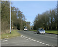
2010 : A4 near Rudloe
At the top of Box Hill.
Heading east toward Corsham and Chippenham.
Image: © Maurice Pullin
Taken: 2 Mar 2010
0.23 miles
2
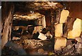
Brewers Yard Quarry
This photo shows some blocks of stone that were never removed from this quarry.
Owned by a Mr Brewer who was a contractor on the Box Tunnel construction is unusual as it is on two levels.
Image: © Derek Hawkins
Taken: Unknown
0.24 miles