IMAGES TAKEN NEAR TO
Selwood Close, SWINDON, SN1 2QQ
Introduction
This page details the photographs taken nearby to Selwood Close, SN1 2QQ by members of the Geograph project.
The Geograph project started in 2005 with the aim of publishing, organising and preserving representative images for every square kilometre of Great Britain, Ireland and the Isle of Man.

There are currently over 7.5m images from over14,400 individuals and you can help contribute to the project by visiting https://www.geograph.org.uk
Image Map
Images are licensed for reuse under creativecommons.org/licenses/by-sa/2.0
Notes
- Clicking on the map will re-center to the selected point.
- The higher the marker number, the further away the image location is from the centre of the postcode.
Image Listing (16 Images Found)
Images are licensed for reuse under creativecommons.org/licenses/by-sa/2.0
Image
Details
Distance
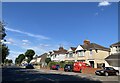
2
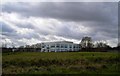
Marsh Farm Lane
Housing in Marsh Farm Lane, completed in 2001.
Image: © Ian Capper
Taken: 14 Jul 2022
0.15 miles
3
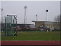
Athletics track in Swindon
View across an athletics track to the County Ground, the home of Swindon Town FC.
Image: © Andrew Smith
Taken: 4 Feb 2006
0.16 miles
4
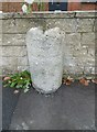
Milestone, Swindon
Carved stone post by the UC road (was A361), Swindon UA; Shrivenham Road, against the front wall of No 80. The eroded inscription once showed mileages to Swindon (1) and Highworth (5). Probably C19, not listed by Historic England.
Milestone Society ID: WI_SNLC01
Part of a national survey by the Milestone Society: https://www.milestonesociety.co.uk/
Image: © Mike Faherty
Taken: 7 Oct 2019
0.16 miles
5
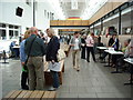
U3A Freshers' Fair, St. Joseph's Catholic College
Swindon University of the Third Age (U3A) Freshers' Fair at St.Joseph's Catholic College. http://www.swindonu3a.org.uk/
Image: © Vieve Forward
Taken: 30 Aug 2014
0.16 miles
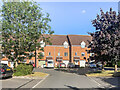
7
Thring Townsend, Drakes Meadow, Penny Lane, Swindon
These are the fairly new offices for a prominent local firm of solicitors. Not on the maps yet.
Image: © Brian Robert Marshall
Taken: 24 Feb 2007
0.19 miles
8
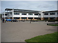
St. Joseph's Catholic College
The rear entrance of St.Joseph's Catholic College, one of Swindon's main secondary schools. http://www.stjosephs.swindon.sch.uk/
Image: © Vieve Forward
Taken: 30 Aug 2014
0.20 miles
9
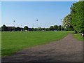
Football pitch adjacent to The County Ground
Image: © David Martin
Taken: 22 May 2012
0.20 miles
10
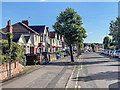
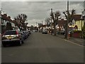
Shrivenham Road
c.1930s housing in Shrivenham Road. Earlier maps show the road pre-development as Stratton Road.
Image: © Ian Capper
Taken: 14 Jul 2022
0.22 miles