IMAGES TAKEN NEAR TO
Copse Avenue, SWINDON, SN1 2QF
Introduction
This page details the photographs taken nearby to Copse Avenue, SN1 2QF by members of the Geograph project.
The Geograph project started in 2005 with the aim of publishing, organising and preserving representative images for every square kilometre of Great Britain, Ireland and the Isle of Man.

There are currently over 7.5m images from over14,400 individuals and you can help contribute to the project by visiting https://www.geograph.org.uk
Image Map
Images are licensed for reuse under creativecommons.org/licenses/by-sa/2.0
Notes
- Clicking on the map will re-center to the selected point.
- The higher the marker number, the further away the image location is from the centre of the postcode.
Image Listing (48 Images Found)
Images are licensed for reuse under creativecommons.org/licenses/by-sa/2.0
Image
Details
Distance
1
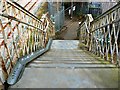
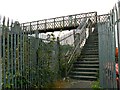
Footbridge, Paddington to the West railway, Stratton, Swindon (7)
At right are the steps seen here Image The bridge will be taken down soon as part of the electrification project underway on the railway.
Image: © Brian Robert Marshall
Taken: 16 Sep 2014
0.05 miles
2
Footbridge over the railway in Swindon
Image: © Steve Daniels
Taken: 2 Sep 2009
0.05 miles
3
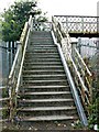
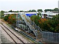
Footbridge, Paddington to the West railway, Stratton, Swindon (6)
These are the steps down from the footbridge on the Stratton Road side. The bridge is to be taken down at some point in the near future as part of the electrification project underway on the railway. It's too low to allow the overhead power lines to pass beneath. The gutter at the side is to make it easier to transport push-bikes over the bridge.
Image: © Brian Robert Marshall
Taken: 16 Sep 2014
0.05 miles
4
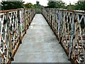
Footbridge, Paddington to the West railway, Stratton, Swindon (4)
This is a view south across the footbridge with properties in Copse Avenue visible in the background. The bridge is soon to be taken down as part of a project to electrify the railway.
Image: © Brian Robert Marshall
Taken: 16 Sep 2014
0.05 miles
5
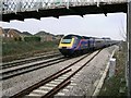
Paddington to the West Country and Wales railway
Looking west, Swindon Station is out of view about 1.6 kilometres down the line from here. This image was obtained from outside the boundary fence protecting the railway.
Image: © Brian Robert Marshall
Taken: 15 Dec 2006
0.06 miles
6
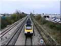
West Country and Wales to Paddington railway
Facing towards London, the train is on the 'down' line slowing before its next stop at Swindon.
Image: © Brian Robert Marshall
Taken: 15 Dec 2006
0.06 miles
7
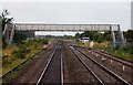
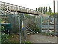
New footbridge, Paddington to the West railway, Stratton, Swindon (2)
The footbridge is being built as a replacement for the existing footbridge http://www.geograph.org.uk/photo/4172155 which has to go as it is too low for the overhead electrical cables that will later be installed as part of the upgrading of the Paddington to the West railway. In the background is part of a small industrial estate.
Image: © Brian Robert Marshall
Taken: 16 Sep 2014
0.06 miles
8
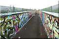
Graffiti-covered footbridge across the railway near Gipsy Lane
Image: © Gareth James
Taken: 5 Jan 2023
0.06 miles
9
Footbridge, Paddington to the West railway, Stratton, Swindon (3)
At right are the steps seen here Image The bridge will be taken down soon as part of the electrification project underway on the railway.
Image: © Brian Robert Marshall
Taken: 16 Sep 2014
0.06 miles
10
Footbridge, Paddington to the West railway, Stratton, Swindon (1)
The bridge has to come down soon as part of the electrification of the railway project.
Image: © Brian Robert Marshall
Taken: 16 Sep 2014
0.07 miles