IMAGES TAKEN NEAR TO
Graham Street, SWINDON, SN1 2EX
Introduction
This page details the photographs taken nearby to Graham Street, SN1 2EX by members of the Geograph project.
The Geograph project started in 2005 with the aim of publishing, organising and preserving representative images for every square kilometre of Great Britain, Ireland and the Isle of Man.

There are currently over 7.5m images from over14,400 individuals and you can help contribute to the project by visiting https://www.geograph.org.uk
Image Map
Images are licensed for reuse under creativecommons.org/licenses/by-sa/2.0
Notes
- Clicking on the map will re-center to the selected point.
- The higher the marker number, the further away the image location is from the centre of the postcode.
Image Listing (159 Images Found)
Images are licensed for reuse under creativecommons.org/licenses/by-sa/2.0
Image
Details
Distance
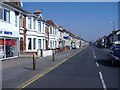
1
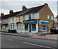
Swindon Launderette, Swindon
The launderette is on the corner of Manchester Road and Salisbury Street.
Image: © Jaggery
Taken: 14 Apr 2013
0.07 miles
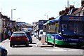
2
County Road and mural, Swindon
Houses at northern end of County Road (A4259). http://www.geograph.org.uk/photo/1375521 to a closeup view of the Arkells Brewery mural.
Image: © Jaggery
Taken: 12 Mar 2011
0.07 miles
4
Manchester Road houses, Swindon
Viewed from the corner of Rosebery Street looking towards County Road.
Image: © Jaggery
Taken: 14 Apr 2013
0.08 miles
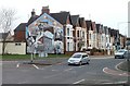
5
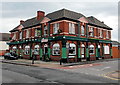
The Tap & Barrel, Swindon
The large pub is on the corner of Manchester Road and Gladstone Street.
Image: © Jaggery
Taken: 14 Apr 2013
0.08 miles
6
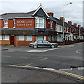
Sharland Roofing, Swindon
On the corner of Manchester Road and County Road.
Image: © Jaggery
Taken: 14 Apr 2013
0.09 miles
7
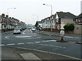
North along County Road, Swindon
The mini-roundabout is at the junction with Manchester Road, out of view to the left. County Road was, before the war, almost the easternmost edge of the town.
Image: © Brian Robert Marshall
Taken: 31 Dec 2008
0.09 miles
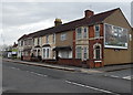
8
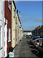
Gooch Street, Swindon
This area of Swindon was developed in the latter part of the 19th century primarily because of the coming of the railway from London to the west of England. Large numbers of terraced houses were built to provide accommodation for workers at the large railway factory built by I K Brunel to provide everything needed to run a railway. Many of these houses remain. Most of them have small front gardens http://www.geograph.org.uk/photo/986163 but a few terraces have none as is the case here where the houses open directly onto the street. Gooch Street is named after one of Brunel's early recruits, Sir Daniel Gooch, who decided that Swindon would be an ideal location for the necessary works. There is an excellent wiki article that gives a potted history of the Swindon works here http://en.wikipedia.org/wiki/Swindon_railway_works
Image: © Brian Robert Marshall
Taken: 10 Sep 2009
0.09 miles