IMAGES TAKEN NEAR TO
Colbourne Street, SWINDON, SN1 2EQ
Introduction
This page details the photographs taken nearby to Colbourne Street, SN1 2EQ by members of the Geograph project.
The Geograph project started in 2005 with the aim of publishing, organising and preserving representative images for every square kilometre of Great Britain, Ireland and the Isle of Man.

There are currently over 7.5m images from over14,400 individuals and you can help contribute to the project by visiting https://www.geograph.org.uk
Image Map
Images are licensed for reuse under creativecommons.org/licenses/by-sa/2.0
Notes
- Clicking on the map will re-center to the selected point.
- The higher the marker number, the further away the image location is from the centre of the postcode.
Image Listing (109 Images Found)
Images are licensed for reuse under creativecommons.org/licenses/by-sa/2.0
Image
Details
Distance
7

Mural on the side
A house on County Road with a mural of Arkell's brewery
Image: © Steve Daniels
Taken: 21 Aug 2011
0.06 miles
8
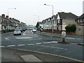
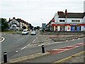
North along County Road, Swindon
The mini-roundabout is at the junction with Manchester Road, out of view to the left. County Road was, before the war, almost the easternmost edge of the town.
Image: © Brian Robert Marshall
Taken: 31 Dec 2008
0.06 miles
9
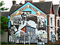
Mural, County Road, Swindon
The mural has been here for several years. It was the work of Ken White, a former local railwayman turned artist http://www.swindonweb.com/?m=8&s=9&ss=266&c=1101&t=Ken+White it appears that the mural has recently been re-painted, although probably not by the original artist. The brewery it represents is still going and is still independent http://www.geograph.org.uk/photo/753002
Image: © Brian Robert Marshall
Taken: 28 Jun 2009
0.07 miles
10
Station Road junction with County Road, Swindon
Station Road leaves the frame to the right and leads to Swindon Junction railway station. County Road leads away from the viewpoint. The mural on the left can be seen in more detail here http://www.geograph.org.uk/photo/1375521
Image: © Brian Robert Marshall
Taken: 28 Jun 2009
0.07 miles