IMAGES TAKEN NEAR TO
Clarence Street, SWINDON, SN1 2DJ
Introduction
This page details the photographs taken nearby to Clarence Street, SN1 2DJ by members of the Geograph project.
The Geograph project started in 2005 with the aim of publishing, organising and preserving representative images for every square kilometre of Great Britain, Ireland and the Isle of Man.

There are currently over 7.5m images from over14,400 individuals and you can help contribute to the project by visiting https://www.geograph.org.uk
Image Map
Images are licensed for reuse under creativecommons.org/licenses/by-sa/2.0
Notes
- Clicking on the map will re-center to the selected point.
- The higher the marker number, the further away the image location is from the centre of the postcode.
Image Listing (366 Images Found)
Images are licensed for reuse under creativecommons.org/licenses/by-sa/2.0
Image
Details
Distance
1
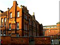
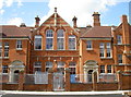
Former Clarence Street School, Swindon (1)
The school was built in 1897 and closed as a school about ninety years later. It is now used by the local authority social services department. The more modern building in the background is also used by the local council. Opened in 1990 it is called 'Wat Tyler House' after the poll tax rebel of 1381.
Image: © Brian Robert Marshall
Taken: 6 Feb 2007
0.02 miles
2
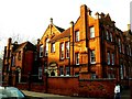
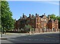
Former Clarence Street School, Swindon (2)
A wider view of the former junior school.
Image: © Brian Robert Marshall
Taken: 6 Feb 2007
0.02 miles
5
Clarence Street school
The side elevation of this imposing red brick school as seen from, somewhat appropriately, Euclid Street. These premises are currently being renovated. See Image] for the front view details.
Image: © Neil Owen
Taken: 10 Jun 2014
0.03 miles
6
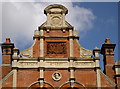
Former Clarence Street School
Now occupied by offices of Swindon Borough Council. Built 1895 for the Swindon School Board, Listed Grade II.
Image: © Alan Murray-Rust
Taken: 15 Jul 2022
0.03 miles
7
Red brick school
Clarence Street was a slightly less busy street back in the day - today the four lanes of traffic rush by. But in the late 1800s, Swindon was enjoying a boom in population and the need for extra schools was apparent. In 1897, this imposing school was built for 840 older pupils and 320 infants at a cost of £12,091. It may have been coincidence but there used to be a brick and tiles works a short distance to the east of it. See Image] for the side in Euclid Street.
Image: © Neil Owen
Taken: 10 Jun 2014
0.04 miles
8
Someone please buy us
Two lions with concerns on their minds. Looks like La Dolce Vita didn't last too long.
Image: © Neil Owen
Taken: 10 Jun 2014
0.04 miles
9
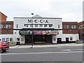
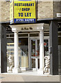
Old Cinema
On Princes Street in Swindon, what looks like a former cinema now what looks like an entertainment facility.
Image: © Bill Nicholls
Taken: 16 Mar 2019
0.05 miles
10
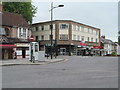
An empire long gone
The very boring sixties building seen here on the corner of Groundwell Road and Princes Street replaced the Empire Theatre which stood on the same site when I was a child in the fifties. The junction is at the bottom of Victoria Road, a hill leading towards Old Town, and down which a tram once ran out of control and tipped over on this corner.
Image: © Gordon Hatton
Taken: 23 May 2017
0.05 miles