IMAGES TAKEN NEAR TO
Alfred Street, SWINDON, SN1 2BP
Introduction
This page details the photographs taken nearby to Alfred Street, SN1 2BP by members of the Geograph project.
The Geograph project started in 2005 with the aim of publishing, organising and preserving representative images for every square kilometre of Great Britain, Ireland and the Isle of Man.

There are currently over 7.5m images from over14,400 individuals and you can help contribute to the project by visiting https://www.geograph.org.uk
Image Map
Images are licensed for reuse under creativecommons.org/licenses/by-sa/2.0
Notes
- Clicking on the map will re-center to the selected point.
- The higher the marker number, the further away the image location is from the centre of the postcode.
Image Listing (275 Images Found)
Images are licensed for reuse under creativecommons.org/licenses/by-sa/2.0
Image
Details
Distance
2
Fleming Way, Swindon
The houses are on Medgbury Road which is behind the barrier.
Image: © David Howard
Taken: 11 Jun 2023
0.06 miles
3
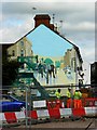
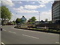
Golden Lion Bridge Mural at Whalebridge Roundabout, Swindon
Information below was added by a site visitor in March 2012.
The Golden Lion Bridge Mural was painted on the end of a house near Whalebridge Roundabout, Swindon, by Ken White in 1976. It depicts the bridge that once spanned the canal where the Parade intersects with Regent Street and Bridge Street. The mural has recently been restored. http://www.swindonlink.com/features/famous-landmark-to-be-revived-by-swindon-artist
Image: © Alby
Taken: 29 Dec 2008
0.06 miles
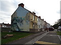
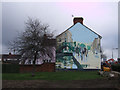
4
Mural, Medgbury Road, Swindon
The mural is the work of the celebrated locally-based but internationally-known artist, Ken White http://www.kenwhitemurals.co.uk/home/ It depicts the Golden Lion Bridge which once carried people over the long-gone (from here) Wilts and Berks Canal. The original bridge was here http://www.geograph.org.uk/photo/622406 Arguably Ken White's best-known work is the 'Scarlet Lady' to be found on Virgin Airlines planes such as this one photographed by Janet Lute http://www.geograph.org.uk/photo/609040 The construction workers in the image are altering the road layout hereabouts as part of the regeneration of this part of Swindon.
Image: © Brian Robert Marshall
Taken: 11 Aug 2011
0.06 miles
5
Golden Lion mural by Ken White, Whalebridge roundabout
Restored in 2009, 33 years after it was first painted, this was artist Ken White's first mural. Golden Lion Bridge crossed the Wilts and Berks canal at the junction of Regent Street and Bridge Street.
It was demolished in 1918 following the 1914 closure of the canal. http://www.flickr.com/photos/swindonlocal/3693890062/
Image: © Vieve Forward
Taken: 7 Feb 2012
0.06 miles
6
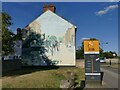
Mural on the end gable of Medgebury Road
See Image for some additional notes.
Image: © Stephen Craven
Taken: 14 Jul 2022
0.06 miles
7
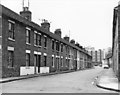
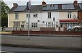
The demolished south side of Medgbury Road, Swindon
A Victorian street of terraced housing in the town centre. The gardens on the south side used to back onto the Wilts & Berks Canal, which closed here around 1927. On its route Fleming Way has been built. This photograph was taken in April 1980, from the junction with Medgbury Place. Within a year or so, the south side of the street had been demolished, but the other side was left standing. The houses were built of red brick, and had two bedrooms upstairs. As can be seen, the entrance doors opened directly onto the street.
Further along on this side were Cetus Buildings, which had been built as accommodation for canal workers. There was also the Whale Inn, but all these were demolished much earlier, to facilitate road improvements. Much of the site of the demolished terraced houses is now occupied by Cockram Court, a sheltered housing scheme owned by Swindon Borough Council.
Image: © P L Chadwick
Taken: Unknown
0.06 miles
8
West along Fleming Way, Swindon
Fleming Way is built on the line of a long-gone canal, the Wiltshire and Berkshire, which once ran through the heart of Swindon. Parts of it still exist outside the town and restoration is an ongoing project http://www.geograph.org.uk/photo/496686 http://www.geograph.org.uk/photo/1099315 and http://www.geograph.org.uk/photo/1362014 Thirty odd years ago at this viewpoint the view would have been quite different. Fleming Way was there but the residential block to the right wasn't. Instead you would have seen a row of rather jerry-built cottages that were demolished in what was the last of the clearance areas to be made in Swindon under the Housing Acts in about 1980. At the left was a large factory, Garrards, whose frontage came to the edge of Fleming Way and which would have obscured Jury's hotel just to the left of centre if it had been there, which it wasn't, as it was only completed in 2009 on the site of a Ford dealership. The office block further to the left would also have been lost to view although it may have been there then. It certainly looks 1970s in appearance. It is home to the Benefits Agency, formerly DSS, DHSS or simply 'the social'.
Image: © Brian Robert Marshall
Taken: 20 Dec 2009
0.07 miles
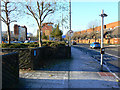
9
Whale Bridge Roundabout, Swindon May 2011 (2 of 2)
The roundabout provides pedestrian access across the junction of four main roads, Fleming Way (x2), Princes Street and Corporation Street - but not for much longer. As part of the regeneration of the centre of Swindon the roundabout is scheduled to be filled in and has already been so.
Image: © Brian Robert Marshall
Taken: 3 May 2011
0.07 miles
10
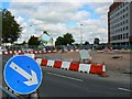
Whale Bridge Roundabout, Swindon August 2011 (2 of 2)
A few weeks on from May http://www.geograph.org.uk/photo/2547829 and the pedestrian subways are all filled in. The work on the roundabout has necessitated some lane closures and patience is required when negotiating the junction.
The Ken White mural in the background can be seen in more detail here http://www.geograph.org.uk/photo/2548187
Image: © Brian Robert Marshall
Taken: 11 Aug 2011
0.07 miles