IMAGES TAKEN NEAR TO
Top Lane, MELKSHAM, SN12 8QU
Introduction
This page details the photographs taken nearby to Top Lane, SN12 8QU by members of the Geograph project.
The Geograph project started in 2005 with the aim of publishing, organising and preserving representative images for every square kilometre of Great Britain, Ireland and the Isle of Man.

There are currently over 7.5m images from over14,400 individuals and you can help contribute to the project by visiting https://www.geograph.org.uk
Image Map
Images are licensed for reuse under creativecommons.org/licenses/by-sa/2.0
Notes
- Clicking on the map will re-center to the selected point.
- The higher the marker number, the further away the image location is from the centre of the postcode.
Image Listing (14 Images Found)
Images are licensed for reuse under creativecommons.org/licenses/by-sa/2.0
Image
Details
Distance
1
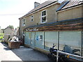
The Toast Office
Whitley's former post office was based in this modern building. It has since been turned over into a catering business, which has evolved into this current offering - which seems to have closed.
Image: © Neil Owen
Taken: 15 Jun 2021
0.04 miles
2
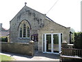
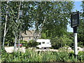
Whitley Methodist Church
The Wesleyan Methodist church stands near the north of the village, and sadly has a rather illegible datestone but is certainly a nineteenth century building. At the far end of the outer wall is a benchmark - see Image
Image: © Neil Owen
Taken: 15 Jun 2021
0.05 miles
3
The Pear Tree, Whitley
The inn, which also offers accommodation is on Top Lane.
Image: © Maigheach-gheal
Taken: 11 Apr 2010
0.05 miles
4
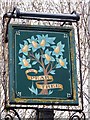
Sign for the Pear Tree
The name suggests the presence of such a tree, or an indication that perry, a drink like cider, only made from pears instead of apples, was for sale.
Image: © Maigheach-gheal
Taken: 11 Apr 2010
0.06 miles
5
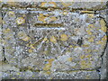
Benchmark on the Methodist church wall
Whitley Methodists congregate here; on the far end of the boundary wall is this benchmark dating from post-war times. See https://www.bench-marks.org.uk/bm152991 for the entry in the Benchmark Database and Image] for a location view.
Image: © Neil Owen
Taken: 15 Jun 2021
0.06 miles
6
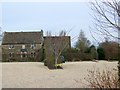
The Pear Tree Inn
The pub is actually set a fair distance from the main road, with a car park nearer. The pub is a fairly recent development of a seventeenth century farmhouse.
Image: © Neil Owen
Taken: 15 Jun 2021
0.07 miles
7
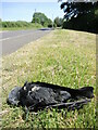
The end of the road on Top Lane
A sad victim lies at the roadside, resumably a vehicle strike.
Image: © Neil Owen
Taken: 15 Jun 2021
0.09 miles
8
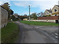
Middle Lane towards Top Lane, Whitley
Looking NW along Middle Lane past the right turn into Brookfield Rise.
Image: © Jaggery
Taken: 3 Nov 2014
0.14 miles
9
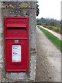
Postbox, Whitley
A George VI reign postbox set into a stone wall near the Pear Tree Inn.
Image: © Maigheach-gheal
Taken: 11 Apr 2010
0.15 miles
10
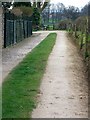
Driveway, Whitley
The drive serves as a footpath that takes walkers towards Lagard Farm and Folly Lane Farm.
Image: © Maigheach-gheal
Taken: 11 Apr 2010
0.16 miles