IMAGES TAKEN NEAR TO
Broughton Gifford, MELKSHAM, SN12 8NR
Introduction
This page details the photographs taken nearby to SN12 8NR by members of the Geograph project.
The Geograph project started in 2005 with the aim of publishing, organising and preserving representative images for every square kilometre of Great Britain, Ireland and the Isle of Man.

There are currently over 7.5m images from over14,400 individuals and you can help contribute to the project by visiting https://www.geograph.org.uk
Image Map
Images are licensed for reuse under creativecommons.org/licenses/by-sa/2.0
Notes
- Clicking on the map will re-center to the selected point.
- The higher the marker number, the further away the image location is from the centre of the postcode.
Image Listing (7 Images Found)
Images are licensed for reuse under creativecommons.org/licenses/by-sa/2.0
Image
Details
Distance
1
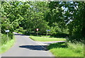
2008 : Road junction near Ganbrook Farm
We came from South Wraxall, the road ahead goes to Atworth and to the right for Little Chalfield and Holt.
Image: © Maurice Pullin
Taken: 19 Jun 2008
0.04 miles
2
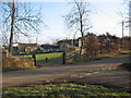
Ganbrook Farm
A view looking east towards Ganbrook Farm, with staddle stones lining the drive.
Image: © Phil Williams
Taken: 3 Mar 2006
0.04 miles
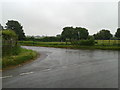
3
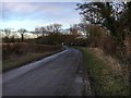
Road heading to Atworth
Road heading to Atworth passing the turn to Poor House Cottage
Image: © Shaun Ferguson
Taken: 5 Jan 2018
0.05 miles
4
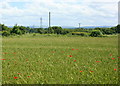
2008 : Wheatfield near Ganbrook Farm
With poppies and a view south over Wiltshire.
Image: © Maurice Pullin
Taken: 19 Jun 2008
0.06 miles
5
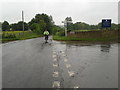
Cycling from the direction of Bradford-on-Avon on a wet day
Image: © Rob Purvis
Taken: 11 Jun 2013
0.12 miles
7
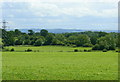
2008 : Farmland near Ganbrook
Looking toward the Salisbury Plain escarpment.
Image: © Maurice Pullin
Taken: 19 Jun 2008
0.24 miles