IMAGES TAKEN NEAR TO
Brook Close, MELKSHAM, SN12 8FG
Introduction
This page details the photographs taken nearby to Brook Close, SN12 8FG by members of the Geograph project.
The Geograph project started in 2005 with the aim of publishing, organising and preserving representative images for every square kilometre of Great Britain, Ireland and the Isle of Man.

There are currently over 7.5m images from over14,400 individuals and you can help contribute to the project by visiting https://www.geograph.org.uk
Image Map
Images are licensed for reuse under creativecommons.org/licenses/by-sa/2.0
Notes
- Clicking on the map will re-center to the selected point.
- The higher the marker number, the further away the image location is from the centre of the postcode.
Image Listing (32 Images Found)
Images are licensed for reuse under creativecommons.org/licenses/by-sa/2.0
Image
Details
Distance
1
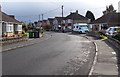
Bend in Southbrook Road, Melksham
Looking south along Southbrook Road.
Image: © Jaggery
Taken: 3 Nov 2014
0.03 miles
2
Northern end of Addison Road, Melksham
Looking south from the corner of Dunch Lane.
Image: © Jaggery
Taken: 3 Nov 2014
0.09 miles
3
Wires and houses in Southbrook Road, Melksham
The course of Southbrook Road is roughly parallel with South Brook, about 100 metres to the east.
Image: © Jaggery
Taken: 3 Nov 2014
0.10 miles
4
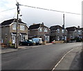
Roundponds houses in Melksham
On the north side of this http://www.geograph.org.uk/photo/4231948 grass rectangle.
Image: © Jaggery
Taken: 3 Nov 2014
0.11 miles
5
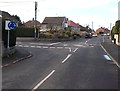
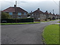
Junction of Dunch Lane and Southbrook Road, Melksham
Southbrook Road is left of the mini-roundabout.
Image: © Jaggery
Taken: 3 Nov 2014
0.12 miles
6
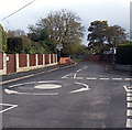
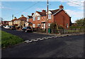
Dunch Lane mini-roundabout in Melksham
At the Southbrook Road junction (on the right).
Image: © Jaggery
Taken: 3 Nov 2014
0.12 miles
7
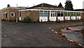
NW corner of the former George Ward School, Melksham
Viewed from the edge of Bath Road in early November 2014. Named after Alderman George Ward, JP, of Melksham, who was involved in local public affairs for over 50 years, the school replaced Shurnhold Secondary School. George Ward School has now closed, replaced by the new Melksham Oak Community School at Bowerhill on the SE side of town. A nearby board shows that the 12.7 hectares (31.4 acres) site has been sold for residential development.
Image: © Jaggery
Taken: 3 Nov 2014
0.13 miles
8
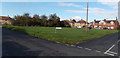
Grass rectangle, Roundponds, Melksham
Viewed across the SE corner of the rectangle measuring about 50 metres by 45 metres.
The name sign on the grass shows ROUNDPONDS.
Image: © Jaggery
Taken: 3 Nov 2014
0.13 miles
9

Traffic restrictions along Dunch Lane, Melksham
No motor vehicles ahead from 8.15am-8.45am and 3pm-3.30pm (Mondays-Fridays).
No vehicles heavier than 7.5 tonnes at any other time.
The brick walls are on a bridge over South Brook. http://www.geograph.org.uk/photo/4231806
Image: © Jaggery
Taken: 3 Nov 2014
0.13 miles
10
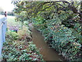
South Brook, Melksham
A small tributary of the River Avon, viewed from Dunch Lane near Southbrook Road.
Image: © Jaggery
Taken: 3 Nov 2014
0.13 miles