IMAGES TAKEN NEAR TO
Northbrook Road, MELKSHAM, SN12 8DU
Introduction
This page details the photographs taken nearby to Northbrook Road, SN12 8DU by members of the Geograph project.
The Geograph project started in 2005 with the aim of publishing, organising and preserving representative images for every square kilometre of Great Britain, Ireland and the Isle of Man.

There are currently over 7.5m images from over14,400 individuals and you can help contribute to the project by visiting https://www.geograph.org.uk
Image Map
Images are licensed for reuse under creativecommons.org/licenses/by-sa/2.0
Notes
- Clicking on the map will re-center to the selected point.
- The higher the marker number, the further away the image location is from the centre of the postcode.
Image Listing (27 Images Found)
Images are licensed for reuse under creativecommons.org/licenses/by-sa/2.0
Image
Details
Distance
1
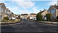
Northbrook Road, Melksham
Cul-de-sac on the north side of Dunch Lane.
Image: © Jaggery
Taken: 3 Nov 2014
0.02 miles
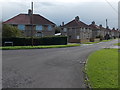
2
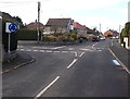
Junction of Dunch Lane and Southbrook Road, Melksham
Southbrook Road is left of the mini-roundabout.
Image: © Jaggery
Taken: 3 Nov 2014
0.03 miles
3
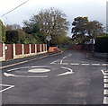
Dunch Lane mini-roundabout in Melksham
At the Southbrook Road junction (on the right).
Image: © Jaggery
Taken: 3 Nov 2014
0.03 miles
4
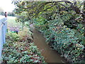
South Brook, Melksham
A small tributary of the River Avon, viewed from Dunch Lane near Southbrook Road.
Image: © Jaggery
Taken: 3 Nov 2014
0.04 miles
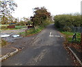
5

Traffic restrictions along Dunch Lane, Melksham
No motor vehicles ahead from 8.15am-8.45am and 3pm-3.30pm (Mondays-Fridays).
No vehicles heavier than 7.5 tonnes at any other time.
The brick walls are on a bridge over South Brook. http://www.geograph.org.uk/photo/4231806
Image: © Jaggery
Taken: 3 Nov 2014
0.05 miles
6
Northern end of Addison Road, Melksham
Looking south from the corner of Dunch Lane.
Image: © Jaggery
Taken: 3 Nov 2014
0.07 miles
7
Dunch Lane towards Beanacre Road, Melksham
Looking ENE from near this http://www.geograph.org.uk/photo/4231799 mini-roundabout.
Image: © Jaggery
Taken: 3 Nov 2014
0.07 miles
8
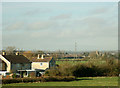
2008 : North of Melksham
View from the railway bridge on Dunch Lane, the church in the right distance is at Shaw.
Image: © Maurice Pullin
Taken: 8 Feb 2008
0.07 miles
9
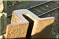
2008 : Broad Gauge Railway Line (detail)
During the 1890s the Great Western Railway was forced by Act of Parliament to change from their original 7ft 1in gauge to standard gauge, as a result they were left with miles of useless railway line. Much of it eventually went for scrap but some was recycled as structural reinforcement and as various types of fence post, as here.
This gives us an opportunity so see the cross-section of broad gauge railway line as it was used in the 19th century.
Cast iron is an excellent material for use outside as it is not eaten away by rust when unprotected. When open to the elements it forms a thin patina of rust which protects the metal from further rusting.
It does, however, have one big disadvantage. Although very strong, especially in compression, it is brittle and will snap without warning before it bends.
Image: © Maurice Pullin
Taken: 8 Feb 2008
0.11 miles
10
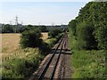
Chippenham to Trowbridge branch line at Melksham
Image: © Doug Lee
Taken: 11 Jul 2006
0.12 miles