IMAGES TAKEN NEAR TO
Shurnhold, MELKSHAM, SN12 8DF
Introduction
This page details the photographs taken nearby to Shurnhold, SN12 8DF by members of the Geograph project.
The Geograph project started in 2005 with the aim of publishing, organising and preserving representative images for every square kilometre of Great Britain, Ireland and the Isle of Man.

There are currently over 7.5m images from over14,400 individuals and you can help contribute to the project by visiting https://www.geograph.org.uk
Image Map
Images are licensed for reuse under creativecommons.org/licenses/by-sa/2.0
Notes
- Clicking on the map will re-center to the selected point.
- The higher the marker number, the further away the image location is from the centre of the postcode.
Image Listing (17 Images Found)
Images are licensed for reuse under creativecommons.org/licenses/by-sa/2.0
Image
Details
Distance
1
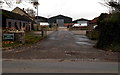
Shurnhold Farm Business Park, Melksham
On the SW side of the A365.
Image: © Jaggery
Taken: 3 Nov 2014
0.00 miles
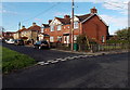
2
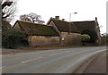
Grade II listed Shurnhold Farmhouse, Melksham
Viewed across the A365. The early 18th century farmhouse was Grade II listed in 1950.
Image: © Jaggery
Taken: 3 Nov 2014
0.07 miles
3
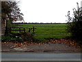
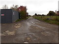
Gate and stile to a public footpath, Shurnhold, Melksham
On the SW side of the A365.
Image: © Jaggery
Taken: 3 Nov 2014
0.08 miles
4
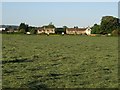
Houses on Shurnhold
The houses are on the A365 northwest of Melksham. Seen across an intervening meadow from a parallel footpath between Roundponds Farm and Shaw.
Image: © Derek Harper
Taken: 30 May 2009
0.10 miles
5
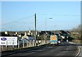
2008 : Shurnhold, Melksham
We are on Bath Road near the railway bridge, Shurnhold is at the bottom of the hill. The road is the A365 to Box.
There is an excellent recycling centre on the right here.
Image: © Maurice Pullin
Taken: 1 Feb 2008
0.12 miles
6
Roundponds Farm access road, Melksham
From the A365 Shurnhold, where a sign shows
The Berrifield Herd of Pedigree Holstein Friesians, W.D. & M. Guley & Sons, Roundponds Farm.
Image: © Jaggery
Taken: 3 Nov 2014
0.13 miles
7
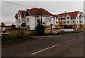
Blenheim House Care Centre, Melksham
On the south side of the A365, here named Shurnhold, near Shurnhold Farm.
Image: © Jaggery
Taken: 3 Nov 2014
0.14 miles
8
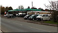
Victoria Motors, Shurnhold, Melksham
On the north side of the A365, here named Shurnhold, near Shurnhold Farm.
Image: © Jaggery
Taken: 3 Nov 2014
0.14 miles
9
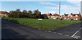
Grass rectangle, Roundponds, Melksham
Viewed across the SE corner of the rectangle measuring about 50 metres by 45 metres.
The name sign on the grass shows ROUNDPONDS.
Image: © Jaggery
Taken: 3 Nov 2014
0.15 miles
10
Roundponds houses in Melksham
On the north side of this http://www.geograph.org.uk/photo/4231948 grass rectangle.
Image: © Jaggery
Taken: 3 Nov 2014
0.16 miles