IMAGES TAKEN NEAR TO
Speedwell Close, MELKSHAM, SN12 7TE
Introduction
This page details the photographs taken nearby to Speedwell Close, SN12 7TE by members of the Geograph project.
The Geograph project started in 2005 with the aim of publishing, organising and preserving representative images for every square kilometre of Great Britain, Ireland and the Isle of Man.

There are currently over 7.5m images from over14,400 individuals and you can help contribute to the project by visiting https://www.geograph.org.uk
Image Map
Images are licensed for reuse under creativecommons.org/licenses/by-sa/2.0
Notes
- Clicking on the map will re-center to the selected point.
- The higher the marker number, the further away the image location is from the centre of the postcode.
Image Listing (21 Images Found)
Images are licensed for reuse under creativecommons.org/licenses/by-sa/2.0
Image
Details
Distance
1
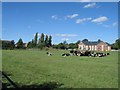
The Spa Medical Centre
The new Spa Medical Centre (named after the three buildings of the abortive Melksham Spa a half kilometre to the SE) marks the current eastern edge of Melksham. Houses from the Snowberry Lane development are visible to the left of the image.
Image: © Doug Lee
Taken: 28 Aug 2005
0.07 miles
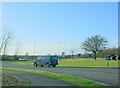
2
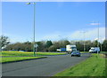
2009 : Roundabout at the eastern end of the Melksham bypass (2)
Image: © Maurice Pullin
Taken: 20 Jan 2009
0.08 miles
3
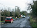
2009 : Roundabout at the eastern end of the Melksham bypass (3)
The road to Bowerhill is the next turning out to the left.
Image: © Maurice Pullin
Taken: 20 Jan 2009
0.10 miles
4
![Once the main road [2]](https://s0.geograph.org.uk/geophotos/05/66/13/5661368_35f677c1_120x120.jpg)
Once the main road [2]
Once part of the A365 road, this short stretch has been bypassed and the main road now runs to a large roundabout. Seen here looking north west towards Melksham.
Image: © Michael Dibb
Taken: 12 Jan 2018
0.12 miles
5
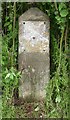
Old Milestone by the B3112, Spa Road, Melksham parish
Stone post (plate lost) by the B3112 (was A365), in parish of MELKSHAM (WEST WILTSHIRE District), Spa Road; Melksham; 50m North of Snowberry Lane roundabout, on embankment behind ditch, on West side of road. Melksham plate, erected by the Melksham turnpike trust in the 19th century.
Inscription once read:-
(BATH)
(13)
Carved benchmark front lower right, rivet hole on top.
Milestone Society National ID: WI_LB_BADZ13.
Image: © M Faherty
Taken: 30 May 2008
0.13 miles
6
2009 : Spa Road, Melksham
Formerly the A365. The bit that was cut off when the new bypass was built.
Image: © Maurice Pullin
Taken: 20 Jan 2009
0.13 miles
7
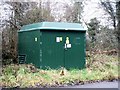
Enclosed sub station
The small enclosed sub station is a recent addition to Bath Road.
Image: © Michael Dibb
Taken: 12 Jan 2018
0.15 miles
8

2009 : Roundabout at the eastern end of the Melksham bypass
There are people who don't like bypasses and climb trees and things to stop them being built, I'm not keen on them either but they make a big difference to life in places like Melksham.
We are looking out along the A365 to Sells Green and Martinslade where it joins the A361.
Image: © Maurice Pullin
Taken: 20 Jan 2009
0.15 miles
9
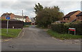
Longleaze Lane, Melksham
Longleaze Lane heads NE away from Spa Road. Below the street name sign, a red sign shows
PRIVATE LANE
RESIDENTS PARKING ONLY.
Image: © Jaggery
Taken: 5 Nov 2014
0.16 miles
10
![Bath Road houses [3]](https://s0.geograph.org.uk/geophotos/05/66/13/5661384_cb00fc74_120x120.jpg)
Bath Road houses [3]
Numbers 399 and 400 Bath Road, a pair of semi-detached houses built circa 1815 as part of a short lived spa development. Listed, grade II, with details at: https://www.historicengland.org.uk/listing/the-list/list-entry/1194751
Image: © Michael Dibb
Taken: 12 Jan 2018
0.17 miles