IMAGES TAKEN NEAR TO
Chapel Lane, MELKSHAM, SN12 7PX
Introduction
This page details the photographs taken nearby to Chapel Lane, SN12 7PX by members of the Geograph project.
The Geograph project started in 2005 with the aim of publishing, organising and preserving representative images for every square kilometre of Great Britain, Ireland and the Isle of Man.

There are currently over 7.5m images from over14,400 individuals and you can help contribute to the project by visiting https://www.geograph.org.uk
Image Map
Images are licensed for reuse under creativecommons.org/licenses/by-sa/2.0
Notes
- Clicking on the map will re-center to the selected point.
- The higher the marker number, the further away the image location is from the centre of the postcode.
Image Listing (3 Images Found)
Images are licensed for reuse under creativecommons.org/licenses/by-sa/2.0
Image
Details
Distance
1
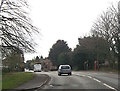
A350 entering Beanacre
Phone box in village visible
Image: © John Firth
Taken: 11 Apr 2013
0.12 miles
2
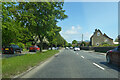
A350 heading north, Beanacre
Towards Chippenham.
Image: © Robin Webster
Taken: 30 May 2021
0.17 miles
3
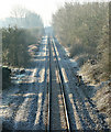
2008 : Chippenham to Melksham Railway near Beanacre
Looking south toward Melksham from Westlands Lane railway bridge.
Image: © Maurice Pullin
Taken: 17 Feb 2008
0.23 miles