IMAGES TAKEN NEAR TO
Gloucester Square, MELKSHAM, SN12 7NJ
Introduction
This page details the photographs taken nearby to Gloucester Square, SN12 7NJ by members of the Geograph project.
The Geograph project started in 2005 with the aim of publishing, organising and preserving representative images for every square kilometre of Great Britain, Ireland and the Isle of Man.

There are currently over 7.5m images from over14,400 individuals and you can help contribute to the project by visiting https://www.geograph.org.uk
Image Map
Images are licensed for reuse under creativecommons.org/licenses/by-sa/2.0
Notes
- Clicking on the map will re-center to the selected point.
- The higher the marker number, the further away the image location is from the centre of the postcode.
Image Listing (6 Images Found)
Images are licensed for reuse under creativecommons.org/licenses/by-sa/2.0
Image
Details
Distance
1
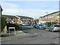
2009 : Marti Close, Melksham
A turning off Blackmore Road.
Image: © Maurice Pullin
Taken: 20 Jan 2009
0.07 miles
2
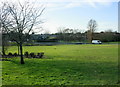
2009 : Public open space, Melksham
One of the few bright spots in a rather dull new housing development east of Melksham.
Image: © Maurice Pullin
Taken: 20 Jan 2009
0.07 miles
3
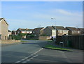
2009 : Blackmore Road, Melksham
At the junction with Mills Road.
Image: © Maurice Pullin
Taken: 20 Jan 2009
0.12 miles
4
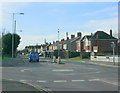
2009 : A3102 Sandridge Road, Melksham
Taken from the junction of Blackmore Road.
Image: © Maurice Pullin
Taken: 20 Jan 2009
0.15 miles
5
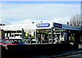
2009 : Melksham Co-op, Blackmore Road
Much changed over the years following a period of poor management during the 1950s and 1960s.
Image: © Maurice Pullin
Taken: 20 Jan 2009
0.21 miles
6
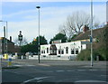
2009 : Foresters Arms, Sandridge Road, Melksham
Said to be a lively spot, but don't believe me see http://www.beerintheevening.com/pubs/s/10/10603/Foresters_Arms/Melksham
Image: © Maurice Pullin
Taken: 20 Jan 2009
0.24 miles