IMAGES TAKEN NEAR TO
Leaze Road, MELKSHAM, SN12 7EX
Introduction
This page details the photographs taken nearby to Leaze Road, SN12 7EX by members of the Geograph project.
The Geograph project started in 2005 with the aim of publishing, organising and preserving representative images for every square kilometre of Great Britain, Ireland and the Isle of Man.

There are currently over 7.5m images from over14,400 individuals and you can help contribute to the project by visiting https://www.geograph.org.uk
Image Map
Images are licensed for reuse under creativecommons.org/licenses/by-sa/2.0
Notes
- Clicking on the map will re-center to the selected point.
- The higher the marker number, the further away the image location is from the centre of the postcode.
Image Listing (6 Images Found)
Images are licensed for reuse under creativecommons.org/licenses/by-sa/2.0
Image
Details
Distance
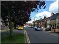
1
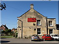
Pig and Whistle, Melksham
The pub is on the corner of Forest Road and Littlejohn Avenue.
Image: © Derek Harper
Taken: 30 May 2009
0.13 miles
2
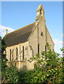
St Andrew's Church, Melksham - viewed from east
Image: © Steve Roberts
Taken: 5 Jul 2016
0.14 miles
3
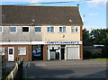
Forest Launderette, Church Road, Melksham
Launderette serving the Melksham Forest suburb. Railings in left foreground are the corner of St Andrew's churchyard.
Image: © Steve Roberts
Taken: 5 Jul 2016
0.14 miles
4
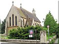
St Andrews Church on Church Lane
One of two churches on Church Lane - the other being a methodist chapel
Image: © Doug Lee
Taken: 4 Jun 2006
0.14 miles
6
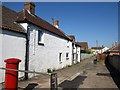
Former post office, Melksham
An older house at right angles to Woodrow Road by a path to Bowden Crescent.
Image: © Derek Harper
Taken: 30 May 2009
0.16 miles