IMAGES TAKEN NEAR TO
Oregano Close, SN12 6WW
Introduction
This page details the photographs taken nearby to Oregano Close, SN12 6WW by members of the Geograph project.
The Geograph project started in 2005 with the aim of publishing, organising and preserving representative images for every square kilometre of Great Britain, Ireland and the Isle of Man.

There are currently over 7.5m images from over14,400 individuals and you can help contribute to the project by visiting https://www.geograph.org.uk
Image Map
Images are licensed for reuse under creativecommons.org/licenses/by-sa/2.0
Notes
- Clicking on the map will re-center to the selected point.
- The higher the marker number, the further away the image location is from the centre of the postcode.
Image Listing (9 Images Found)
Images are licensed for reuse under creativecommons.org/licenses/by-sa/2.0
Image
Details
Distance
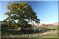
1
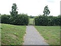
Footpath leaves the road
The footpath starts at Eastern Way and heads towards Redstocks and Seend.
Image: © Michael Dibb
Taken: 8 Jul 2017
0.18 miles
2
![Oakfield Stadium [1]](https://s3.geograph.org.uk/geophotos/05/45/91/5459167_060bbba0_120x120.jpg)
Oakfield Stadium [1]
The newly built stadium is home to Melksham Town Football Club and Melksham Rugby Football Club. Seen from the path.
Image: © Michael Dibb
Taken: 8 Jul 2017
0.19 miles
3
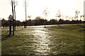
Gossamer covered grass
The banking beside the new road is covered in gossamer threads.
Image: © Doug Lee
Taken: 11 Nov 2012
0.20 miles
4
![Oakfield Stadium [2]](https://s2.geograph.org.uk/geophotos/05/45/91/5459190_4bf200f1_120x120.jpg)
Oakfield Stadium [2]
The newly built stadium is home to Melksham Town Football Club and Melksham Rugby Football Club. Seen from the path.
Image: © Michael Dibb
Taken: 8 Jul 2017
0.20 miles
5
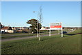
New road and housing estate
The Gateway housing estate is still under construction
Image: © Doug Lee
Taken: 11 Nov 2012
0.20 miles
6
Green corridor
Clackers Brook creates a corridor of green through the bland modern housing.
There has been a great deal of development to the east of Melksham in recent years with some 2,000 new homes built or planned by 2026.
Image: © Michael Dibb
Taken: 8 Jul 2017
0.23 miles
7
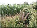
Through the stile
The old concrete squeeze stile gives access to the next field. The footpath had not been restored through the crop and the only way was around the field edge.
Image: © Michael Dibb
Taken: 8 Jul 2017
0.23 miles
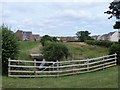
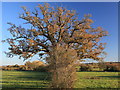
8
View along the old field boundary towards The Gateway
The trees and remains of the old field boundary now separate the existing houses which have been built since 2009 from the new build of the third phase of development of this housing estate which is still under construction in 2012.
Image: © Doug Lee
Taken: 11 Nov 2012
0.24 miles
9
Field Boundary near The Gateway
Not long ago the fields here were a few hundred metres from any right of way. Now, the new housing estate of The Gateway lies just behind the point from which this image was taken
Image: © Doug Lee
Taken: 11 Nov 2012
0.25 miles