IMAGES TAKEN NEAR TO
Cedar Close, MELKSHAM, SN12 6UZ
Introduction
This page details the photographs taken nearby to Cedar Close, SN12 6UZ by members of the Geograph project.
The Geograph project started in 2005 with the aim of publishing, organising and preserving representative images for every square kilometre of Great Britain, Ireland and the Isle of Man.

There are currently over 7.5m images from over14,400 individuals and you can help contribute to the project by visiting https://www.geograph.org.uk
Image Map
Images are licensed for reuse under creativecommons.org/licenses/by-sa/2.0
Notes
- Clicking on the map will re-center to the selected point.
- The higher the marker number, the further away the image location is from the centre of the postcode.
Image Listing (138 Images Found)
Images are licensed for reuse under creativecommons.org/licenses/by-sa/2.0
Image
Details
Distance
1
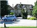
Melksham House, Melksham
Melksham House, west of the Market Place
This 18th century house, used as a social club by the Avon Rubber Company between 1920 and 2011, is now in Wiltshire Council ownership. On the left is part of a public car park.
Grade II listed - https://www.historicengland.org.uk/listing/the-list/list-entry/1285783
Image: © Steve Roberts
Taken: 26 Aug 2016
0.10 miles
2
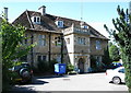
Facade of Melksham House, Melksham
This 18th century house, used as a social club by the Avon Rubber Company between 1920 and 2011, is now in Wiltshire Council ownership. The porch is a 19th century addition.
Grade II listed - https://www.historicengland.org.uk/listing/the-list/list-entry/1285783
Image: © Steve Roberts
Taken: 26 Aug 2016
0.10 miles
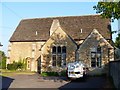
3
Now dwellings
This interesting former school has been converted into dwellings.
Image: © Michael Dibb
Taken: 20 May 2018
0.14 miles
4
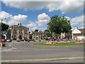
Melksham Town Hall
The junction of King Street, Spa Road and the High Street meets here with the Town Hall, Assembly Hall and, behind the Assembly Hall, the sports centre.
Image: © Doug Lee
Taken: 28 Aug 2005
0.14 miles
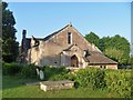
5
Once a tithe barn
This circa 15th century tithe barn was converted into a school in 1878 and is now dwellings. Listed, grade II, with details at: https://www.historicengland.org.uk/listing/the-list/list-entry/1364169
Image: © Michael Dibb
Taken: 20 May 2018
0.15 miles
6
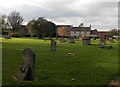
St Michael's Churchyard, Melksham
On the south side of the Church of England Parish Church of St Michael and All Angels. http://www.geograph.org.uk/photo/4237227
Image: © Jaggery
Taken: 5 Nov 2014
0.15 miles
7
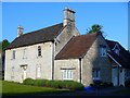
The Grove
This late 18th/early 19th century detached house is listed, grade II, with details at: https://www.historicengland.org.uk/listing/the-list/list-entry/1021706
Image: © Michael Dibb
Taken: 20 May 2018
0.16 miles
8
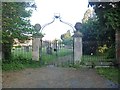
Gateway to the church
These lovely gate piers, gates and railings give access to the churchyard from Place Road. Listed, grade II, with details at: https://www.historicengland.org.uk/listing/the-list/list-entry/1364146
Image: © Michael Dibb
Taken: 20 May 2018
0.17 miles
9
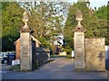
East gateway to Melksham House
Melksham House is owned by Wiltshire Council and is home to various sports clubs. The 18th century gate piers and wrought iron gates remain in situ. Listed, grade II, with details at: https://www.historicengland.org.uk/listing/the-list/list-entry/1364144
Image: © Michael Dibb
Taken: 20 May 2018
0.17 miles
10
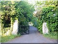
North gateway to Melksham House
Melksham House is owned by Wiltshire Council and is home to various sports clubs. The 18th century gate piers remain in situ albeit almost hidden in the foliage. Listed, grade II, with details at: https://www.historicengland.org.uk/listing/the-list/list-entry/1194321
Image: © Michael Dibb
Taken: 20 May 2018
0.17 miles