IMAGES TAKEN NEAR TO
Halifax Road, MELKSHAM, SN12 6SN
Introduction
This page details the photographs taken nearby to Halifax Road, SN12 6SN by members of the Geograph project.
The Geograph project started in 2005 with the aim of publishing, organising and preserving representative images for every square kilometre of Great Britain, Ireland and the Isle of Man.

There are currently over 7.5m images from over14,400 individuals and you can help contribute to the project by visiting https://www.geograph.org.uk
Image Map
Images are licensed for reuse under creativecommons.org/licenses/by-sa/2.0
Notes
- Clicking on the map will re-center to the selected point.
- The higher the marker number, the further away the image location is from the centre of the postcode.
Image Listing (6 Images Found)
Images are licensed for reuse under creativecommons.org/licenses/by-sa/2.0
Image
Details
Distance
1
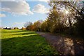
Pathway between Falcon Way and the parkland
Image: © Doug Lee
Taken: 11 Nov 2012
0.14 miles
2
![Bowerhill Houses [1]](https://s0.geograph.org.uk/geophotos/05/79/65/5796548_5f545e99_120x120.jpg)
Bowerhill Houses [1]
Bowerhill is effectively a small satellite town of Melksham. This area of Bowerhill was developed in the early/mid 1990s.
Image: © Michael Dibb
Taken: 20 May 2018
0.18 miles
3
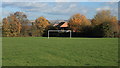
View over the goal to Roundway Hill
The parkland in the middle of the Bowerhill sports a single set of goalposts.
Image: © Doug Lee
Taken: 11 Nov 2012
0.20 miles
4
![Bowerhill houses [2]](https://s3.geograph.org.uk/geophotos/05/79/65/5796555_f23447d7_120x120.jpg)
Bowerhill houses [2]
Bowerhill is effectively a small satellite town of Melksham. This area of Bowerhill was developed in the mid 1990s.
Image: © Michael Dibb
Taken: 20 May 2018
0.22 miles
5
![Bowerhill houses [3]](https://s2.geograph.org.uk/geophotos/05/79/65/5796558_6fd076dc_120x120.jpg)
Bowerhill houses [3]
Bowerhill is effectively a small satellite town of Melksham. This area of Bowerhill was developed in the early/mid 1990s.
Image: © Michael Dibb
Taken: 20 May 2018
0.23 miles
6
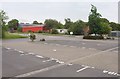
Car park, Lancaster Park Industrial Estate
Car parking areas off Lancaster Road. The industrial estate was built on the site of RAF Melksham http://www.wellho.net/share/bowerhill.html .
Image: © Derek Harper
Taken: 20 Jul 2011
0.24 miles