IMAGES TAKEN NEAR TO
Rusty Lane, MELKSHAM, SN12 6NS
Introduction
This page details the photographs taken nearby to Rusty Lane, SN12 6NS by members of the Geograph project.
The Geograph project started in 2005 with the aim of publishing, organising and preserving representative images for every square kilometre of Great Britain, Ireland and the Isle of Man.

There are currently over 7.5m images from over14,400 individuals and you can help contribute to the project by visiting https://www.geograph.org.uk
Image Map
Images are licensed for reuse under creativecommons.org/licenses/by-sa/2.0
Notes
- Clicking on the map will re-center to the selected point.
- The higher the marker number, the further away the image location is from the centre of the postcode.
Image Listing (135 Images Found)
Images are licensed for reuse under creativecommons.org/licenses/by-sa/2.0
Image
Details
Distance
1
![Seend buildings [4]](https://s1.geograph.org.uk/geophotos/04/22/63/4226397_db9eb900_120x120.jpg)
Seend buildings [4]
In Rusty lane, this recent building serves as a community centre, village hall and as a pavilion for the adjacent recreation ground.
Seend is a hilltop village about 3¾ miles west of Devizes and some 5¾ miles northeast of Trowbridge. The name is from the Old English word ‘sende’ meaning a sandy place. It lies astride the A361 road from Devizes to Trowbridge, which was once the main road from London to Bath. The village has medieval origins, but there is evidence of occupation in Neolithic times. Farming, especially of wool, and later iron ore brought prosperity to Seend, which today is essentially a commuter village.
Image: © Michael Dibb
Taken: 26 Oct 2014
0.04 miles
2
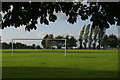
Irene Usher Memorial Pavilion and recreation ground, Seend
The recreation ground (Seend Lye Field) is used for football and cricket matches; a cricket match against Broughton Gifford has just taken place. Irene Usher Memorial Pavilion, adjoining it and used today as the cricket pavilion, was paid for by extensive fundraising, including large events such as steam fairs and opened in 1973. https://www.seendlyefield.org/irene-usher-memorial-pavilion.html Irene Usher was a local resident in the early part of the 20th century, who often hosted village events at her house and was a benefactor of the Lye Field https://www.wiltshiretimes.co.uk/news/2388677.nostalgia/ .
Image: © HelenK
Taken: 4 May 2014
0.04 miles
3
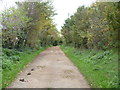
Start of bridleway
Although paved for a short distance, Rusty Lane becomes a bridleway. It would be possible to ride on bridleways as far as Melksham.
Image: © Michael Dibb
Taken: 26 Oct 2014
0.05 miles
4
![Five ways to go [2]](https://s0.geograph.org.uk/geophotos/04/22/70/4227036_8c5b5025_120x120.jpg)
Five ways to go [2]
Seen from the point where three bridleways and two footpaths meet, this is the bridleway to Seend.
Image: © Michael Dibb
Taken: 26 Oct 2014
0.05 miles
5
![Five ways to go [3]](https://s1.geograph.org.uk/geophotos/04/22/70/4227037_ad386804_120x120.jpg)
Five ways to go [3]
Seen from the point where three bridleways and two footpaths meet, this is the bridleway to Bollands Hill.
Image: © Michael Dibb
Taken: 26 Oct 2014
0.07 miles
6
![Five ways to go [1]](https://s2.geograph.org.uk/geophotos/04/22/70/4227034_c5d914f0_120x120.jpg)
Five ways to go [1]
Three bridleways and two footpaths meet at this point.
Image: © Michael Dibb
Taken: 26 Oct 2014
0.08 miles
7
![Five ways to go [6]](https://s1.geograph.org.uk/geophotos/04/22/70/4227041_c2da085b_120x120.jpg)
Five ways to go [6]
Seen from the point where three bridleways and two footpaths meet, this is the footpath to Spout Lane.
Image: © Michael Dibb
Taken: 26 Oct 2014
0.08 miles
8
![Seend ways [5]](https://s1.geograph.org.uk/geophotos/04/22/63/4226385_0752ef15_120x120.jpg)
Seend ways [5]
From the High Street, Rusty Lane leads to the community centre and, beyond, a number of footpath and bridleways.
Seend is a hilltop village about 3¾ miles west of Devizes and some 5¾ miles northeast of Trowbridge. The name is from the Old English word ‘sende’ meaning a sandy place. It lies astride the A361 road from Devizes to Trowbridge, which was once the main road from London to Bath. The village has medieval origins, but there is evidence of occupation in Neolithic times. Farming, especially of wool, and later iron ore brought prosperity to Seend, which today is essentially a commuter village.
Image: © Michael Dibb
Taken: 26 Oct 2014
0.08 miles
9
![Five ways to go [5]](https://s0.geograph.org.uk/geophotos/04/22/70/4227040_0dbc9454_120x120.jpg)
Five ways to go [5]
Seen from the point where three bridleways and two footpaths meet, this is the footpath to the Kennet & Avon canal (via the entrance-way to Little Foxes Farm).
Image: © Michael Dibb
Taken: 26 Oct 2014
0.09 miles
10
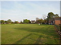
Recreation ground, Seend
Village recreation ground seen from High Street.
Image: © Stephen McKay
Taken: 13 Sep 2011
0.09 miles