
IMAGES TAKEN NEAR TO
Hill Crest, MELKSHAM, SN12 6NL
Introduction
This page details the photographs taken nearby to Hill Crest, SN12 6NL by members of the Geograph project.
The Geograph project started in 2005 with the aim of publishing, organising and preserving representative images for every square kilometre of Great Britain, Ireland and the Isle of Man.

There are currently over 7.5m images from over14,400 individuals and you can help contribute to the project by visiting https://www.geograph.org.uk
Image Map
Images are licensed for reuse under creativecommons.org/licenses/by-sa/2.0
Notes
- Clicking on the map will re-center to the selected point.
- The higher the marker number, the further away the image location is from the centre of the postcode.
Image Listing (113 Images Found)
Images are licensed for reuse under creativecommons.org/licenses/by-sa/2.0
Image
Details
Distance

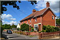
3
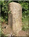
Old Milestone on Bollands Hill, off the A361, Seend
Carved stone post off the A361, in parish of SEEND (KENNET District), opposite Bell Inn junction on Bollands Hill embankment, on North East side of road. Lavington stone, erected by the West Lavington to Seend turnpike trust in the 19th century.
Inscription unknown.
Milestone Society National ID: WI_SELV00.
Image: © M Faherty
Taken: 8 Jun 2007
0.03 miles
5
![Seend features [15]](https://s2.geograph.org.uk/geophotos/07/38/71/7387194_569ff7c3_120x120.jpg)
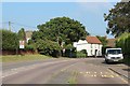
Seend features [15]
This milestone is set in Bollards Hill, near the junction with High Street. Lavington stone, erected by the West Lavington to Seend turnpike trust in the 19th century. Inscription unknown. There is a closer view of the stone at Image
Seend is a hilltop village about 3¾ miles west of Devizes and some 5¾ miles northeast of Trowbridge. The name is from the Old English word ‘sende’ meaning a sandy place. It lies astride the A361 road from Devizes to Trowbridge, which was once the main road from London to Bath. The village has medieval origins, but there is evidence of occupation in Neolithic times. Farming, especially of wool, and later iron ore brought prosperity to Seend, which today is essentially a commuter village.
Image: © Michael Dibb
Taken: 13 Jan 2023
0.03 miles
6
![Seend features [16]](https://s1.geograph.org.uk/geophotos/07/38/71/7387197_fda17917_120x120.jpg)
Seend features [16]
A closer view of the milestone seen in context at Image Set in Bollards Hill, near the junction with High Street. Lavington stone, erected by the West Lavington to Seend turnpike trust in the 19th century. Inscription unknown.
Seend is a hilltop village about 3¾ miles west of Devizes and some 5¾ miles northeast of Trowbridge. The name is from the Old English word ‘sende’ meaning a sandy place. It lies astride the A361 road from Devizes to Trowbridge, which was once the main road from London to Bath. The village has medieval origins, but there is evidence of occupation in Neolithic times. Farming, especially of wool, and later iron ore brought prosperity to Seend, which today is essentially a commuter village.
Image: © Michael Dibb
Taken: 13 Jan 2023
0.03 miles
7
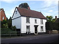
'Wesley Cottage', Seend
From Wiltshire Community web site :
The early Methodist societies in Seend were run by families who had their origins in 17th century Quakerism.
Seend became a missionary centre with Thomas Twinney a most active preacher. It is believed that he lived in a cottage that came to be known as 'Wesley Cottage', where John Wesley preached on 12 March 1749. The Reverend T Jones thought that Seend should be regarded as the 'mother' church of various Wesleyan Societies throughout the locality and in 1757 the membership at Seend numbered 42. Services were held in the village or sometimes at Inmarsh. In 1774 land was leased to David Flower (of Seend Park Farm), local farmer and first trustee, who built the chapel in the High Street which was opened by John Wesley on 4th march 1775. The windows were designed in the 13th century grouped lancet style. There is an 18th century hood over the door and the plaque above the door (commemorating John Wesley's preaching in Seend) was engraved in 1929.
Image: © andrew auger
Taken: 14 Sep 2011
0.03 miles

9
![Seend buildings [6]](https://s1.geograph.org.uk/geophotos/07/38/71/7387177_ed0156f0_120x120.jpg)
Seend buildings [6]
In the grounds of The Hatch Image stands this small outbuilding, probably a stable. Built in the 18th century of rubble stone with some red brick, under a half-hipped stone slate roof. The building adjoins Weavers Cottages. Listed, grade II, with details at: https://historicengland.org.uk/listing/the-list/list-entry/1243883
Seend is a hilltop village about 3¾ miles west of Devizes and some 5¾ miles northeast of Trowbridge. The name is from the Old English word ‘sende’ meaning a sandy place. It lies astride the A361 road from Devizes to Trowbridge, which was once the main road from London to Bath. The village has medieval origins, but there is evidence of occupation in Neolithic times. Farming, especially of wool, and later iron ore brought prosperity to Seend, which today is essentially a commuter village.
Image: © Michael Dibb
Taken: 13 Jan 2023
0.04 miles
10
![Seend features [14]](https://s2.geograph.org.uk/geophotos/07/38/71/7387178_ec0f38b1_120x120.jpg)
Seend features [14]
This Victorian letter box has been inserted into the outbuilding seen at Image
Seend is a hilltop village about 3¾ miles west of Devizes and some 5¾ miles northeast of Trowbridge. The name is from the Old English word ‘sende’ meaning a sandy place. It lies astride the A361 road from Devizes to Trowbridge, which was once the main road from London to Bath. The village has medieval origins, but there is evidence of occupation in Neolithic times. Farming, especially of wool, and later iron ore brought prosperity to Seend, which today is essentially a commuter village.
Image: © Michael Dibb
Taken: 13 Jan 2023
0.04 miles