IMAGES TAKEN NEAR TO
Brindley Close, MELKSHAM, SN12 6GT
Introduction
This page details the photographs taken nearby to Brindley Close, SN12 6GT by members of the Geograph project.
The Geograph project started in 2005 with the aim of publishing, organising and preserving representative images for every square kilometre of Great Britain, Ireland and the Isle of Man.

There are currently over 7.5m images from over14,400 individuals and you can help contribute to the project by visiting https://www.geograph.org.uk
Image Map
Images are licensed for reuse under creativecommons.org/licenses/by-sa/2.0
Notes
- Clicking on the map will re-center to the selected point.
- The higher the marker number, the further away the image location is from the centre of the postcode.
Image Listing (4 Images Found)
Images are licensed for reuse under creativecommons.org/licenses/by-sa/2.0
Image
Details
Distance
1
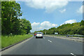
A350 Western Way, Melksham
A bypass to the west of the town.
Image: © Robin Webster
Taken: 30 May 2021
0.16 miles
2
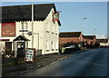
2009 : The New Inn, Semington Road at Berryfield
Near Melksham.
Was tempted by the sign but with roast duck waiting at home was able to resist it.
Image: © Maurice Pullin
Taken: 6 Dec 2009
0.20 miles
3
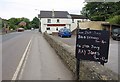
New Inn, Berryfield
A view of Image from the other direction, with a board advertising forthcoming musical entertainment.
Image: © Derek Harper
Taken: 20 Jul 2011
0.21 miles
4
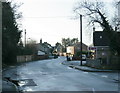
2009 : Semington Road formerly the A350
A bypass now removes responsibility for the A350 from Melksham and Semington.
Semington Road here passes Berryfield but is open to Semington only to buses, cyclists and pedestrians.
Image: © Maurice Pullin
Taken: 6 Dec 2009
0.23 miles