IMAGES TAKEN NEAR TO
David Murray John Tower, SWINDON, SN1 1LU
Introduction
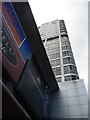
This page details the photographs taken nearby to David Murray John Tower, SN1 1LU by members of the Geograph project.
The Geograph project started in 2005 with the aim of publishing, organising and preserving representative images for every square kilometre of Great Britain, Ireland and the Isle of Man.

There are currently over 7.5m images from over14,400 individuals and you can help contribute to the project by visiting https://www.geograph.org.uk
Image Map
Images are licensed for reuse under creativecommons.org/licenses/by-sa/2.0
Notes
- Clicking on the map will re-center to the selected point.
- The higher the marker number, the further away the image location is from the centre of the postcode.
Image Listing (700 Images Found)
Images are licensed for reuse under creativecommons.org/licenses/by-sa/2.0
Image
Details
Distance
1
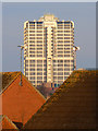
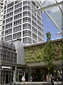
David Murray John (DMJ) Building, Swindon
This building was constructed by the Council in the early 1970s. The lower part is given over to office uses and the upper to flats. Originally the flats, although owned and managed by the local authority, were prestige units. However, I believe they eventually became part of the housing revenue account stock. The building is named after the Town Clerk of Swindon who was the senior council officer from before the war until April 1974 when Swindon Borough Council became Thamesdown Borough Council under the 1974 re-organisation of local government. Sadly he died only a few months later. His achievements were manifold. He purchased a stately home for the Council Image and predicted the eventual demise of the railway works, which closed in 1986, and ensured that other manufacturing industries set up here.
Image: © Brian Robert Marshall
Taken: 19 Feb 2010
0.01 miles
2
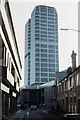
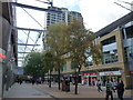
David Murray John Tower
Seen from Queen Street prior to pedestrianisation.
Image: © Martin Addison
Taken: Unknown
0.01 miles
3
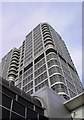
A view up the David Murray John Tower (1)
Viewed facing north-east, this is the nearest thing to a skyscraper in Swindon. For a long view and more information please see this image Image
Image: © Brian Robert Marshall
Taken: 15 Feb 2007
0.02 miles
4
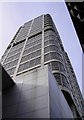
A view up the David Murray John Tower (2)
Another view to the top of the building.
Image: © Brian Robert Marshall
Taken: 15 Feb 2007
0.02 miles
6
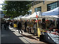
Paving stones, Canal Walk, Swindon
As might be deduced from the name of this pedestrianised shopping area, once upon a time the Wilts and Berks canal ran through this part of Swindon. Although the canal was conceived in 1793 it didn't open until 1810, mainly because of distractions such as the Napoleonic wars. It was never as successful as the better-known Kennet and Avon canal and it fell into disuse in about 1900. More here http://www.wbct.org.uk/history/brief-history-of-wilts-a-berks-canal
Image: © Brian Robert Marshall
Taken: 12 Mar 2010
0.02 miles
7
Steel tower, green shopping
Swindon's Brunel Tower and the shopping area with some rather oddly angled vegetation. See Image] for another look at the greenery.
Image: © Neil Owen
Taken: 10 Jun 2014
0.02 miles
8
Swindon : The Parade
A pedestrian area with shops such as Barratts
Image: © Lewis Clarke
Taken: 22 Oct 2008
0.02 miles
9
Swindon : The David Murray John building
A tall building in Swindon which is also known as the DMJ.
Image: © Lewis Clarke
Taken: 22 Oct 2008
0.02 miles
10
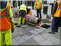
Installing a postbox, Canal Walk, Swindon (1 of 4)
It might look like an unexploded bomb but it is in fact a rather battered-looking EIIR postbox. Here, workers are putting a strap around the box prior to its being hoisted in position by a forklift truck.
Next image: http://www.geograph.org.uk/photo/1749745
Image: © Brian Robert Marshall
Taken: 12 Mar 2010
0.03 miles