IMAGES TAKEN NEAR TO
Brunel Way, CALNE, SN11 9FN
Introduction
This page details the photographs taken nearby to Brunel Way, SN11 9FN by members of the Geograph project.
The Geograph project started in 2005 with the aim of publishing, organising and preserving representative images for every square kilometre of Great Britain, Ireland and the Isle of Man.

There are currently over 7.5m images from over14,400 individuals and you can help contribute to the project by visiting https://www.geograph.org.uk
Image Map
Images are licensed for reuse under creativecommons.org/licenses/by-sa/2.0
Notes
- Clicking on the map will re-center to the selected point.
- The higher the marker number, the further away the image location is from the centre of the postcode.
Image Listing (6 Images Found)
Images are licensed for reuse under creativecommons.org/licenses/by-sa/2.0
Image
Details
Distance

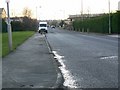
2
2011 : Tractor with a trailer load of animal waste on Stanier Road
The result of a different kind of industry passes through the industrial estate.
Image: © Maurice Pullin
Taken: 6 Nov 2011
0.23 miles
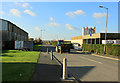
3
Stanier Road, Calne
This is part of Porte Marsh Industrial Estate.
Image: © Brian Robert Marshall
Taken: 10 Dec 2008
0.23 miles
4
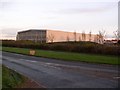
Warehouse beside the Calne bypass (A3102)
Image: © Chris Henley
Taken: 21 Nov 2006
0.23 miles
5
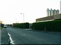
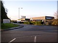
Deceuninck Ltd, Stanier Road, Porte Marsh Industrial Estate, Calne
Stanier Road is the road leading away from the viewpoint. The company identified in the title are manufacturers of plastic building products such as windows. The silos probably contain plastic granules.
Image: © Brian Robert Marshall
Taken: 10 Dec 2008
0.24 miles