IMAGES TAKEN NEAR TO
Martin Way, CALNE, SN11 8PN
Introduction
This page details the photographs taken nearby to Martin Way, SN11 8PN by members of the Geograph project.
The Geograph project started in 2005 with the aim of publishing, organising and preserving representative images for every square kilometre of Great Britain, Ireland and the Isle of Man.

There are currently over 7.5m images from over14,400 individuals and you can help contribute to the project by visiting https://www.geograph.org.uk
Image Map
Images are licensed for reuse under creativecommons.org/licenses/by-sa/2.0
Notes
- Clicking on the map will re-center to the selected point.
- The higher the marker number, the further away the image location is from the centre of the postcode.
Image Listing (10 Images Found)
Images are licensed for reuse under creativecommons.org/licenses/by-sa/2.0
Image
Details
Distance
1
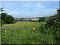
Housing development seen from Low Lane
Image: © Vieve Forward
Taken: 3 Jun 2018
0.18 miles
2
Towards Calne Marsh
Seen from Low Lane. Grass, trees and, in the distance the houses of Calne Marsh.
Image: © Michael Dibb
Taken: 24 May 2017
0.19 miles
4
Along Gregor Drive
Gregor Drive is the main route through this new part of town, linking all the residential cul de sacs which branch off it.
Image: © Des Blenkinsopp
Taken: 2 Jan 2023
0.21 miles
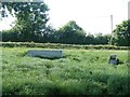
6
Through the gap
The footpath passes through this gap in the fence. A fine tree in the background.
Image: © Michael Dibb
Taken: 24 May 2017
0.23 miles
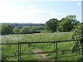
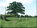
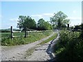
7
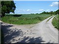
Two ways to go
Low Lane continues towards the left. The track to the right leads to Sands Farm.
Image: © Michael Dibb
Taken: 24 May 2017
0.23 miles
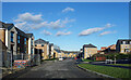
8
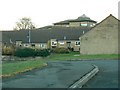
The Glebe, Calne
This part of Calne is local authority housing judging from the style, almost certainly housing for retired people.
Image: © Brian Robert Marshall
Taken: 10 Dec 2008
0.23 miles
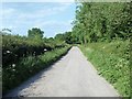
9
The track to Pink Sands
The track leads to a bungalow named Pink Sands.
Image: © Michael Dibb
Taken: 24 May 2017
0.23 miles
