IMAGES TAKEN NEAR TO
Quemerford, CALNE, SN11 8JU
Introduction
This page details the photographs taken nearby to Quemerford, SN11 8JU by members of the Geograph project.
The Geograph project started in 2005 with the aim of publishing, organising and preserving representative images for every square kilometre of Great Britain, Ireland and the Isle of Man.

There are currently over 7.5m images from over14,400 individuals and you can help contribute to the project by visiting https://www.geograph.org.uk
Image Map
Images are licensed for reuse under creativecommons.org/licenses/by-sa/2.0
Notes
- Clicking on the map will re-center to the selected point.
- The higher the marker number, the further away the image location is from the centre of the postcode.
Image Listing (15 Images Found)
Images are licensed for reuse under creativecommons.org/licenses/by-sa/2.0
Image
Details
Distance
1
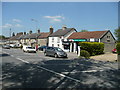
Quemerford Post Office and Stores
On the north side of the A4 south-east of Calne.
Image: © Jonathan Billinger
Taken: 6 May 2008
0.08 miles
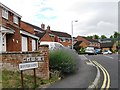
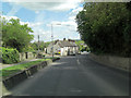
3
Stockley Lane at the junction of Quemerford
Image: © David Howard
Taken: 24 Apr 2016
0.11 miles
4
Houses on Quemerford
The road and village name alike
Image: © David Howard
Taken: 24 Apr 2016
0.12 miles
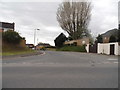
5
A4 northwest of Stockley Lane junction in Quemerford
Image: © Stuart Logan
Taken: 16 May 2012
0.12 miles
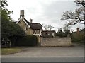
6
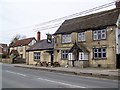
The Talbot Inn, Quemerford
The pub stands beside the A4. The building is 18th century and is built of limestone rubble. For a view of the sign Image
Image: © Maigheach-gheal
Taken: 11 Apr 2010
0.19 miles
7
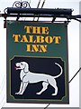
Sign for the Talbot Inn
The talbot was a popular breed of hunting dog, a kind of hound. The dog appears on many pub signs. There are a number of reasons why the dog is used. The dog is the heraldic symbol of the Talbot family, the Earls of Shrewsbury. St Hubert, bred hunting dogs, and had a religious vision while hunting and his dogs became sacred, or it could be directly from this now extinct breed of dog.
Image: © Maigheach-gheal
Taken: 11 Apr 2010
0.19 miles
8
![Alongside the brook [1]](https://s2.geograph.org.uk/geophotos/05/41/79/5417938_a67b5528_120x120.jpg)
Alongside the brook [1]
The footpath runs in a fenced area alongside the oddly named River's Brook.
Image: © Michael Dibb
Taken: 24 May 2017
0.20 miles
9
![Alongside the brook [2]](https://s1.geograph.org.uk/geophotos/05/41/79/5417941_b3ffc986_120x120.jpg)
Alongside the brook [2]
The footpath continues to run alongside the oddly named River's Brook, here through a more wooded area.
Image: © Michael Dibb
Taken: 24 May 2017
0.21 miles
10
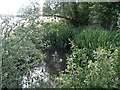
Gently flows the brook
The footpath crosses the oddly named River's Brook.
Image: © Michael Dibb
Taken: 24 May 2017
0.22 miles