IMAGES TAKEN NEAR TO
Marden Way, CALNE, SN11 0RY
Introduction
This page details the photographs taken nearby to Marden Way, SN11 0RY by members of the Geograph project.
The Geograph project started in 2005 with the aim of publishing, organising and preserving representative images for every square kilometre of Great Britain, Ireland and the Isle of Man.

There are currently over 7.5m images from over14,400 individuals and you can help contribute to the project by visiting https://www.geograph.org.uk
Image Map
Images are licensed for reuse under creativecommons.org/licenses/by-sa/2.0
Notes
- Clicking on the map will re-center to the selected point.
- The higher the marker number, the further away the image location is from the centre of the postcode.
Image Listing (47 Images Found)
Images are licensed for reuse under creativecommons.org/licenses/by-sa/2.0
Image
Details
Distance
1
National Cycle Network milepost at Calne
at the start of the cycle route to Chippenham, near the site of the old station and the one-time canal basin.
Image: © Ron Strutt
Taken: 14 Sep 1999
0.06 miles
3
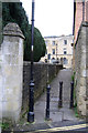
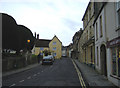
Cobbled lane
One of the many interesting lanes and alleyways in the town centre.
Image: © Roger Cornfoot
Taken: 30 Dec 2006
0.06 miles
4
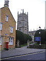
St Mary the Virgin, Calne
A splendid church, approached along a massive avenue of closely clipped yew trees.
Image: © Roger Cornfoot
Taken: 30 Dec 2006
0.06 miles
5
Dusk in Calne
The church lamps flicker into life on a late afternoon in winter.
Image: © Roger Cornfoot
Taken: 30 Dec 2006
0.06 miles
6

Calne Railway Station - the last day
The Calne branch line has been transporting residents of Calne the 5 miles to Chippenham since November 1863 but it is all about to end. It's late afternoon & one of the very last trains has arrived. Closure of 2 nearby RAF bases had meant a significant drop in passenger traffic. Goods facilities had been withdrawn 2 years previously as indicated by the complete absence of sidings in the goods yard. In previous years the Harris Bacon Factory had provided much business, both inwards & outwards. The station building has since long been demolished; initially an industrial estate was built on the site but even that has gone - being replaced by housing development in 2014.
Image: © Martin Tester
Taken: 18 Sep 1965
0.09 miles
7
Probable site of Calne station, 1989
View westward, towards Chippenham. In 1989 nothing could be found of the terminus of the formerly quite important ex-GWR branch from Chippenham, closed since 20/9/65.
Image: © Ben Brooksbank
Taken: 3 Apr 1989
0.09 miles
8

Wenhill Lane
Lane with status of public footpath from Pinhills Farm into Calne town.
Image: © Oliver Dixon
Taken: 7 Jun 2016
0.13 miles
9
![A walk around Calne [56]](https://s1.geograph.org.uk/geophotos/06/76/37/6763765_fce0346c_120x120.jpg)
A walk around Calne [56]
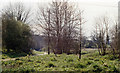
The River Marden, seen from the footpath.
From the town centre the route leads through mostly modern housing before meeting open countryside after crossing the recently built A3102. After passing Calne Sewage Works and crossing both the abandoned Wilts and Berks canal and the River Marden the route joins the dismantled Calne Branch railway which is followed back to the town centre where it crosses the canal again. About 3½ miles.
Image: © Michael Dibb
Taken: 7 Oct 2020
0.16 miles
10
![A walk around Calne [55]](https://s3.geograph.org.uk/geophotos/06/76/37/6763759_38475e66_120x120.jpg)
A walk around Calne [55]
The footpath has left the line of the dismantled railway and is heading towards the River Marden.
From the town centre the route leads through mostly modern housing before meeting open countryside after crossing the recently built A3102. After passing Calne Sewage Works and crossing both the abandoned Wilts and Berks canal and the River Marden the route joins the dismantled Calne Branch railway which is followed back to the town centre where it crosses the canal again. About 3½ miles.
Image: © Michael Dibb
Taken: 7 Oct 2020
0.16 miles