IMAGES TAKEN NEAR TO
Lilac Way, CALNE, SN11 0QG
Introduction
This page details the photographs taken nearby to Lilac Way, SN11 0QG by members of the Geograph project.
The Geograph project started in 2005 with the aim of publishing, organising and preserving representative images for every square kilometre of Great Britain, Ireland and the Isle of Man.

There are currently over 7.5m images from over14,400 individuals and you can help contribute to the project by visiting https://www.geograph.org.uk
Image Map
Images are licensed for reuse under creativecommons.org/licenses/by-sa/2.0
Notes
- Clicking on the map will re-center to the selected point.
- The higher the marker number, the further away the image location is from the centre of the postcode.
Image Listing (21 Images Found)
Images are licensed for reuse under creativecommons.org/licenses/by-sa/2.0
Image
Details
Distance
1
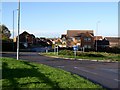
Fynamore Gardens, Calne
This estate was built on the site of the former Fynamore School which later became part of The John Bentley School.
Image: © Chris Henley
Taken: 28 Nov 2006
0.11 miles
2
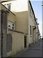
A long way from London, less to Bath
A milestone on London Road. See Image] for a closer look.
Image: © Neil Owen
Taken: 22 Sep 2014
0.15 miles
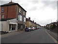
3
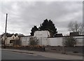
Derelict buildings on London Road, Calne
I am guessing these are soon to be demolished, they look unlikely to be retained although the ivy implies they have been lying disused for a decade or more.
Image: © David Howard
Taken: 24 Apr 2016
0.15 miles
4
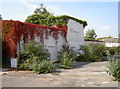
Green reclaims the black
An old petrol station has been cleared out and left to nature. Slowly the vegetation gains more ground.
Image: © Neil Owen
Taken: 22 Sep 2014
0.15 miles
5
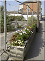
A last vestige of occupation
The old petrol station on the London Road once served the customers. Now, with the garage gone, these blooms make an effort to brighten the site up.
Image: © Neil Owen
Taken: 22 Sep 2014
0.15 miles
6
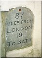
Old Milestone by the A4, London Road, Calne
Calne stone plaque by the A4, in parish of Calne (North Wiltshire District), London Road, in wall of yard to No. 123, 20m West of petrol station, and East of Shelburne Road junction, set into rendered boundary wall, West side of road.
Inscription reads:-
87
MILES FROM
LONDON
19
TO BATH
Surveyed
Milestone Society National ID: WI_lb87
Image: © Milestone Society
Taken: Unknown
0.15 miles
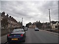
9
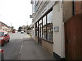
The A4 passes through Calne
On the right is T K Tackle https://tktackle.co.uk/ , a shop selling fishing equipment. Beyond it is the site of the former petrol station seen in Image and Image, now demolished.
Image: © HelenK
Taken: 1 Apr 2021
0.16 miles
10
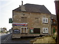
London Road Inn
Where it says - on the London Road!
Image: © Neil Owen
Taken: 22 Sep 2014
0.16 miles