IMAGES TAKEN NEAR TO
Yew Tree Close, CALNE, SN11 0JP
Introduction
This page details the photographs taken nearby to Yew Tree Close, SN11 0JP by members of the Geograph project.
The Geograph project started in 2005 with the aim of publishing, organising and preserving representative images for every square kilometre of Great Britain, Ireland and the Isle of Man.

There are currently over 7.5m images from over14,400 individuals and you can help contribute to the project by visiting https://www.geograph.org.uk
Image Map
Images are licensed for reuse under creativecommons.org/licenses/by-sa/2.0
Notes
- Clicking on the map will re-center to the selected point.
- The higher the marker number, the further away the image location is from the centre of the postcode.
Image Listing (12 Images Found)
Images are licensed for reuse under creativecommons.org/licenses/by-sa/2.0
Image
Details
Distance
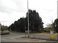
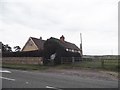
3
Wansdyke Drive at the junction of Curzon Street
Image: © David Howard
Taken: 24 Apr 2016
0.10 miles
4
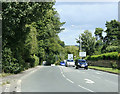
2009 : A4 west of Calne
The byroad on the left leads down to Ratford and Bremhill.
Image: © Maurice Pullin
Taken: 14 Jul 2009
0.15 miles
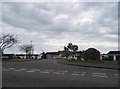
5
![A walk around Calne [12]](https://s2.geograph.org.uk/geophotos/06/76/22/6762230_502e9b40_120x120.jpg)
A walk around Calne [12]
Springfield Drive is a street of typical, bland, modern houses.
From the town centre the route leads through mostly modern housing before meeting open countryside after crossing the recently built A3102. After passing Calne Sewage Works and crossing both the abandoned Wilts and Berks canal and the River Marden the route joins the dismantled Calne Branch railway which is followed back to the town centre where it crosses the canal again. About 3½ miles.
Image: © Michael Dibb
Taken: 7 Oct 2020
0.19 miles
6
![A walk around Calne [10]](https://s3.geograph.org.uk/geophotos/06/76/22/6762211_35a4e4b9_120x120.jpg)
A walk around Calne [10]
From Curzon Street the footpath continues to run alongside the cemetery towards Springfield Drive.
From the town centre the route leads through mostly modern housing before meeting open countryside after crossing the recently built A3102. After passing Calne Sewage Works and crossing both the abandoned Wilts and Berks canal and the River Marden the route joins the dismantled Calne Branch railway which is followed back to the town centre where it crosses the canal again. About 3½ miles.
Image: © Michael Dibb
Taken: 7 Oct 2020
0.20 miles
7
![A walk around Calne [13]](https://s3.geograph.org.uk/geophotos/06/76/22/6762231_4a5e4f6d_120x120.jpg)
A walk around Calne [13]
The path runs along the rear fence of the houses in Braemor Road.
From the town centre the route leads through mostly modern housing before meeting open countryside after crossing the recently built A3102. After passing Calne Sewage Works and crossing both the abandoned Wilts and Berks canal and the River Marden the route joins the dismantled Calne Branch railway which is followed back to the town centre where it crosses the canal again. About 3½ miles.
Image: © Michael Dibb
Taken: 7 Oct 2020
0.21 miles
9
![A walk around Calne [9]](https://s2.geograph.org.uk/geophotos/06/76/22/6762210_95bc0d4e_120x120.jpg)
A walk around Calne [9]
From Curzon Street a footpath runs alongside the cemetery to Springfield Drive.
From the town centre the route leads through mostly modern housing before meeting open countryside after crossing the recently built A3102. After passing Calne Sewage Works and crossing both the abandoned Wilts and Berks canal and the River Marden the route joins the dismantled Calne Branch railway which is followed back to the town centre where it crosses the canal again. About 3½ miles.
Image: © Michael Dibb
Taken: 7 Oct 2020
0.22 miles
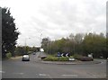
10
![A walk around Calne [11]](https://s1.geograph.org.uk/geophotos/06/76/22/6762213_5fbc6776_120x120.jpg)
A walk around Calne [11]
Lansdowne Square is a small, pleasant green space in the middle of a housing estate.
From the town centre the route leads through mostly modern housing before meeting open countryside after crossing the recently built A3102. After passing Calne Sewage Works and crossing both the abandoned Wilts and Berks canal and the River Marden the route joins the dismantled Calne Branch railway which is followed back to the town centre where it crosses the canal again. About 3½ miles.
Image: © Michael Dibb
Taken: 7 Oct 2020
0.23 miles