IMAGES TAKEN NEAR TO
Elm Grove, CALNE, SN11 0FE
Introduction
This page details the photographs taken nearby to Elm Grove, SN11 0FE by members of the Geograph project.
The Geograph project started in 2005 with the aim of publishing, organising and preserving representative images for every square kilometre of Great Britain, Ireland and the Isle of Man.

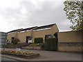
There are currently over 7.5m images from over14,400 individuals and you can help contribute to the project by visiting https://www.geograph.org.uk
Image Map
Images are licensed for reuse under creativecommons.org/licenses/by-sa/2.0
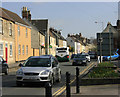
Notes
- Clicking on the map will re-center to the selected point.
- The higher the marker number, the further away the image location is from the centre of the postcode.
Image Listing (70 Images Found)
Images are licensed for reuse under creativecommons.org/licenses/by-sa/2.0
Image
Details
Distance
1
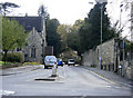
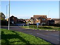
2010 : A3102 arriving at Calne
Joining the A4 having come from Melksham.
Image: © Maurice Pullin
Taken: 16 Apr 2010
0.08 miles
2
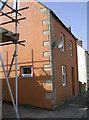
A red coat
This house on London Road has had a nice new coat of paint it seems. Fortunately, a benchmark was made on the coin stones, which have not been touched. See Image
Image: © Neil Owen
Taken: 22 Sep 2014
0.11 miles
3
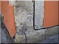
New mark in London Road
This cutmark is a relatively new one, dating from the post-war period. See http://www.bench-marks.org.uk/bm48146 for the entry in the Benchmark Database and Image] for a wider view.
Image: © Neil Owen
Taken: 22 Sep 2014
0.11 miles
4
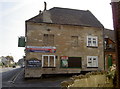
London Road Inn
Where it says - on the London Road!
Image: © Neil Owen
Taken: 22 Sep 2014
0.12 miles
5
Modern houses on New Road, Calne
The actual modern design went out of fashion in the late 20th century and was replaced by mock Victorian which has almost universally taken over for all new houses, possibly inspired by Prince Charles who sponsored an entire fake village which seemed to set it off nationally. I hope the main windows are at the back or these will be very dark inside.
Image: © David Howard
Taken: 24 Apr 2016
0.13 miles
6
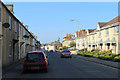
2010 : A4 London Road, Calne
East toward Quemerford, Cherhill and Marlborough.
Seen from the junction with the A3102.
Speed camera sign on the right.
Image: © Maurice Pullin
Taken: 16 Apr 2010
0.13 miles
7
Fynamore Gardens, Calne
This estate was built on the site of the former Fynamore School which later became part of The John Bentley School.
Image: © Chris Henley
Taken: 28 Nov 2006
0.13 miles
8
2012 : A4 London Road, Calne
Entering Calne from the south east, nearing the town centre.
Newer properties to the right face Victorian dwellings (or earlier) on the other side.
Image: © Maurice Pullin
Taken: 11 Mar 2012
0.13 miles
9
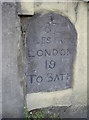
87 miles from London
A milestone set into a wall on the London Road. See Image] for a wider view.
Image: © Neil Owen
Taken: 22 Sep 2014
0.13 miles
10
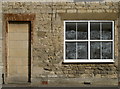
Going hungry
This inauspicious building on the London Road is currently undergoing a change, but the old sign above the door hints it was a bread and cake shop.
Image: © Neil Owen
Taken: 22 Sep 2014
0.13 miles