IMAGES TAKEN NEAR TO
Wessington Park, CALNE, SN11 0AU
Introduction
This page details the photographs taken nearby to Wessington Park, SN11 0AU by members of the Geograph project.
The Geograph project started in 2005 with the aim of publishing, organising and preserving representative images for every square kilometre of Great Britain, Ireland and the Isle of Man.

There are currently over 7.5m images from over14,400 individuals and you can help contribute to the project by visiting https://www.geograph.org.uk
Image Map
Images are licensed for reuse under creativecommons.org/licenses/by-sa/2.0
Notes
- Clicking on the map will re-center to the selected point.
- The higher the marker number, the further away the image location is from the centre of the postcode.
Image Listing (32 Images Found)
Images are licensed for reuse under creativecommons.org/licenses/by-sa/2.0
Image
Details
Distance
1
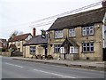
The Talbot Inn, Quemerford
The pub stands beside the A4. The building is 18th century and is built of limestone rubble. For a view of the sign Image
Image: © Maigheach-gheal
Taken: 11 Apr 2010
0.07 miles
2
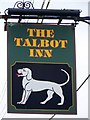
Sign for the Talbot Inn
The talbot was a popular breed of hunting dog, a kind of hound. The dog appears on many pub signs. There are a number of reasons why the dog is used. The dog is the heraldic symbol of the Talbot family, the Earls of Shrewsbury. St Hubert, bred hunting dogs, and had a religious vision while hunting and his dogs became sacred, or it could be directly from this now extinct breed of dog.
Image: © Maigheach-gheal
Taken: 11 Apr 2010
0.07 miles
3
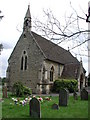
QUEMERFORD, Calne, Wiltshire
The Victorian church of Holy Trinity
Image: © ChurchCrawler
Taken: 19 Jul 2004
0.09 miles
5
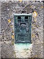
Flush Bracket S0862, Holy Trinity Church
The flush bracket is on the southwest angle of the church. For a wider view of the church Image and http://www.bench-marks.org.uk/bm21173
A bench mark is an Ordnance Survey arrowhead sign found on walls, bridges, churches and specially erected triangulation pillars where the altitude above sea-level has been accurately measured by surveyors. The arrowhead points to a horizontal line above it which marks the exact altitude.
With rivets and pivots there is no datum (horizontal line) cut, the pointed-to horizontal surface defining the datum height.
Image: © Maigheach-gheal
Taken: 11 Apr 2010
0.10 miles
6
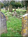
Flowers in the churchyard, Holy Trinity Church
Primroses among the gravestones.
They have two types of flower to ensure pollination by insects with long tongues, such as Bees and Wasps. Ants are attracted to the food stored in the seeds; they also disperse the seeds. In the Middle Ages, a concoction was made from the foliage for treating gout and rheumatism, and an infusion of the roots was used for headaches.
When planted in a garden or hung dried on the front door, primroses will attract the company of Faeries. If you have them growing under your care, do not let them die! The Faeries will be deeply offended by your carelessness.
Image: © Maigheach-gheal
Taken: 11 Apr 2010
0.12 miles
7
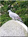
Wood-pigeon, Holy Trinity Church
Sitting on the top of a tomb stone is a big fat woody.
In the eyes of farmers, the innocuous-looking wood-pigeon is undoubtedly 'public enemy number one' among British birds. Townsfolk find this hard to credit when they see the chubby, attractive bird quietly feeding in a local park. But in the country the wood-pigeon does immense damage to crops. It's particularly fond of cereals, potatoes, beans, peas and greens.
Image: © Maigheach-gheal
Taken: 11 Apr 2010
0.12 miles
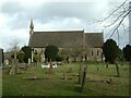
8
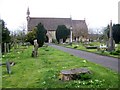
Holy Trinity Church, Quemerford
The church on London Road, was built in 1867 of coursed and squared limestone rubble.
Image: © Maigheach-gheal
Taken: 11 Apr 2010
0.12 miles
9
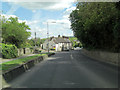
A4 northwest of Stockley Lane junction in Quemerford
Image: © Stuart Logan
Taken: 16 May 2012
0.12 miles
10
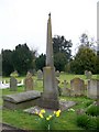
Monument, Holy Trinity Church, Quemerford
A very interesting monument within the churchyard.
Image: © Maigheach-gheal
Taken: 11 Apr 2010
0.12 miles