IMAGES TAKEN NEAR TO
High Street, DEVIZES, SN10 5RS
Introduction
This page details the photographs taken nearby to High Street, SN10 5RS by members of the Geograph project.
The Geograph project started in 2005 with the aim of publishing, organising and preserving representative images for every square kilometre of Great Britain, Ireland and the Isle of Man.

There are currently over 7.5m images from over14,400 individuals and you can help contribute to the project by visiting https://www.geograph.org.uk
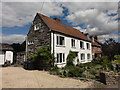
Image Map
Images are licensed for reuse under creativecommons.org/licenses/by-sa/2.0
Notes
- Clicking on the map will re-center to the selected point.
- The higher the marker number, the further away the image location is from the centre of the postcode.
Image Listing (57 Images Found)
Images are licensed for reuse under creativecommons.org/licenses/by-sa/2.0
Image
Details
Distance
1

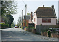
2009 : Rose and Crown, Worton
From its appearance "Further Notice" should not be for long. Hope they will be open for the Beer Festival. http://theroseandcrown-worton.org.uk/
Special note: Friday 13th June will be on a Saturday this year.
Extra special note: The booking was for last year, pity, it was the Wurzels.
Image: © Maurice Pullin
Taken: 20 Apr 2009
0.01 miles
2
2009 : Looking west on Worton High Street
With another view of the Rose & Crown, still closed.
Image: © Maurice Pullin
Taken: 20 Apr 2009
0.01 miles
3
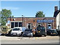
The Old Forge Garage
A local business in Worton village.
Image: © Michael Dibb
Taken: 27 Aug 2017
0.01 miles
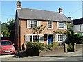
4
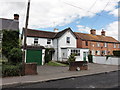
Former Village Shop and Post Office
The white painted front extension with the green door was once the village shop. The entrance led in to a small greengrocer area, before turning left in to the main store. As I recall as you entered, to the left was stationery, under the window was a chest freezer, in front of you was the main counter with confectionery. To the left were shelves of ambient groceries, and on the right hand side of the counter was the Post Office booth. The stores were run by Mr & Mrs. Duck. This was the centre of the village, with the pub to the left of this property and the Coach, Garage & Fuel station to the right.
Image: © Mat Tuck
Taken: 9 Aug 2013
0.02 miles
5
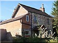
The Lodge
Once the lodge to The Grange, now a private residence.
Image: © Michael Dibb
Taken: 27 Aug 2017
0.02 miles
6
High Street house
Ibsens is No 102, High Street.
Image: © Michael Dibb
Taken: 27 Aug 2017
0.03 miles
7
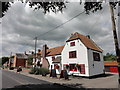
The Rose & Crown public house
Worton High Street's public house called The Rose & Crown. This building has an Ordnance Survey cut bench mark on the front fascia, to the bottom right of the wall. The mark has sympathetically been retained when the building was rendered.
Image: © Mat Tuck
Taken: 9 Aug 2013
0.04 miles
8
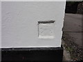
Ordnance Survey cut Bench Mark
Cut in the front street facing wall of The Rose & Crown public house, Worton High Street.
Image: © Mat Tuck
Taken: 9 Aug 2013
0.05 miles
9
The Rose and Crown
This public house is a 17th century timber framed building, much altered in the 20th century. Listed, grade II, with details at: https://www.historicengland.org.uk/listing/the-list/list-entry/1243971
Image: © Michael Dibb
Taken: 27 Aug 2017
0.05 miles
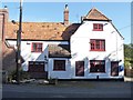
10
Former Public House, Worton High Street
Dwelling which was formerly a Public House called The Royal Oak and was supplied by Ushers of Trowbridge.
Image: © Mat Tuck
Taken: 9 Aug 2013
0.05 miles