IMAGES TAKEN NEAR TO
St. Michaels Close, DEVIZES, SN10 4QJ
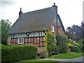
Introduction
This page details the photographs taken nearby to St. Michaels Close, SN10 4QJ by members of the Geograph project.
The Geograph project started in 2005 with the aim of publishing, organising and preserving representative images for every square kilometre of Great Britain, Ireland and the Isle of Man.

There are currently over 7.5m images from over14,400 individuals and you can help contribute to the project by visiting https://www.geograph.org.uk
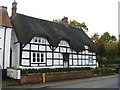
Image Map
Images are licensed for reuse under creativecommons.org/licenses/by-sa/2.0
Notes
- Clicking on the map will re-center to the selected point.
- The higher the marker number, the further away the image location is from the centre of the postcode.
Image Listing (180 Images Found)
Images are licensed for reuse under creativecommons.org/licenses/by-sa/2.0
Image
Details
Distance
1

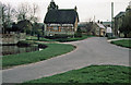
Footpath, Urchfont
A metalled footpath takes walkers to further parts of the village.
Image: © Maigheach-gheal
Taken: 3 Aug 2009
0.04 miles
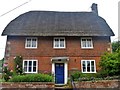
2
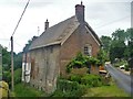
Pear Tree Cottage
Formerly The Retreat, this 17th century cottage has been altered in the 18th and 19th centuries with an extension in the 20th century. There is a delightful bulls-eye window to the attic on the left gable. Listed, grade II, with details at: https://www.historicengland.org.uk/listing/the-list/list-entry/1183243
Image: © Michael Dibb
Taken: 12 Jun 2018
0.04 miles
3
Start of path
A very short path that just cuts the corner from High Street to Friars Lane.
Image: © Michael Dibb
Taken: 12 Jun 2018
0.06 miles
4
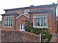
The Old School House
Sited on High Street.
Image: © Michael Dibb
Taken: 12 Jun 2018
0.06 miles
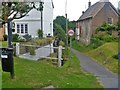
5
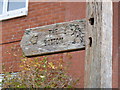
Useful signpost
The way to the bottom!
Image: © Michael Dibb
Taken: 17 Oct 2014
0.07 miles
6
Red Hone Cottage
Alongside the B3098 road is this attractive thatched property. Listed grade II with details at https://historicengland.org.uk/listing/the-list/list-entry/1035880
Image: © Michael Dibb
Taken: 17 Oct 2014
0.07 miles
7
Friars Cottage and The High Street
Looking down the High Street from beside the village pond. The road dipping down beside the cottage is Friars Lane.
Image: © Martin Addison
Taken: Unknown
0.07 miles
8
Wheelwrights
This cottage is mid 18th century and is listed, grade II, with details at: https://www.historicengland.org.uk/listing/the-list/list-entry/1035875
Image: © Michael Dibb
Taken: 12 Jun 2018
0.07 miles
9
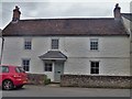
Inglefield
This 18th century house was formerly a butchers shop and farmhouse. Listed, grade II, with details at:
Image: © Michael Dibb
Taken: 12 Jun 2018
0.07 miles
10
Friars Cottage
This fine timber-framed and brick, thatched cottage is late 16th or early 17th century. Listed, grade II, with details at: https://www.historicengland.org.uk/listing/the-list/list-entry/1035872
Image: © Michael Dibb
Taken: 12 Jun 2018
0.08 miles