IMAGES TAKEN NEAR TO
High Street, DEVIZES, SN10 4HE
Introduction
This page details the photographs taken nearby to High Street, SN10 4HE by members of the Geograph project.
The Geograph project started in 2005 with the aim of publishing, organising and preserving representative images for every square kilometre of Great Britain, Ireland and the Isle of Man.

There are currently over 7.5m images from over14,400 individuals and you can help contribute to the project by visiting https://www.geograph.org.uk
Image Map (Loading...)


Getting Data...Please wait
Leaflet Map data © OpenStreetMap
Images are licensed for reuse under creativecommons.org/licenses/by-sa/2.0
Notes
- Clicking on the map will re-center to the selected point.
- The higher the marker number, the further away the image location is from the centre of the postcode.
Image Listing (41 Images Found)
Images are licensed for reuse under creativecommons.org/licenses/by-sa/2.0
Image
Details
Distance
1
![West Lavington houses [21]](https://s0.geograph.org.uk/geophotos/06/36/46/6364668_c86018b0_120x120.jpg)
West Lavington houses [21]
Number 9 (nearest the camera) and number 7 Cheverell Road are two mid 19th century cottages in a row. Listed, grade II, with details at:
https://historicengland.org.uk/listing/the-list/list-entry/1198128
West Lavington, along with Littleton Panell, form a nearly continuous line of ribbon development along the A360 Devizes to Salisbury road on the northern edge of Salisbury Plain. There is evidence of occupation in this area from late Neolithic or early Bronze Age times. The Dauntsey family owned land in the parish from at least 1474 and in 1542 William Dauntsey's bequest founded a school and almshouses.
Image: © Michael Dibb
Taken: 11 Sep 2019
0.06 miles
2
![West Lavington buildings [7]](https://s1.geograph.org.uk/geophotos/06/36/46/6364665_21b589b7_120x120.jpg)
West Lavington buildings [7]
Built in the free Gotic style in 1900 as a Wesleyan Methodist chapel, the site was purchased by the Catholic parish in 1967 after the chapel closed. After repair and refurbishment it reopened as a Catholic church in 1971. The original entrance from Cheverell Road was blocked and entry is now via the hall at the rear - see Image
West Lavington, along with Littleton Panell, form a nearly continuous line of ribbon development along the A360 Devizes to Salisbury road on the northern edge of Salisbury Plain. There is evidence of occupation in this area from late Neolithic or early Bronze Age times. The Dauntsey family owned land in the parish from at least 1474 and in 1542 William Dauntsey's bequest founded a school and almshouses.
Image: © Michael Dibb
Taken: 11 Sep 2019
0.08 miles
3
![A walk from West Lavington to the Plain and return [13]](https://s1.geograph.org.uk/geophotos/06/46/43/6464341_fb8cb4d5_120x120.jpg)
A walk from West Lavington to the Plain and return [13]
As the path ascends Strawberry Hill, the views open out. The buildings of Dauntsey's School are in the middle distance. On the skyline at the left edge of the image is the distinctive clump of trees of Oliver's Castle an Iron Age hillfort. Just right of centre can be seen the white horse on Roundway Hill above Devizes, almost 7 miles distant.
From West Lavington the walk follows the Wessex Ridgeway long distance path up to Littleton Down on Salisbury Plain. Then along the Imber Range Perimeter Path before descending via a byway and a bridleway to the start. About 5½ miles.
Image: © Michael Dibb
Taken: 14 Apr 2020
0.09 miles
4
![Path leaves the road [2]](https://s1.geograph.org.uk/geophotos/06/36/46/6364661_5148b29c_120x120.jpg)
Path leaves the road [2]
From Cheverell Road this footpath runs across Dauntsey's School behind the buildings facing High Street to Sunnyside.
West Lavington, along with Littleton Panell, form a nearly continuous line of ribbon development along the A360 Devizes to Salisbury road on the northern edge of Salisbury Plain. There is evidence of occupation in this area from late Neolithic or early Bronze Age times. The Dauntsey family owned land in the parish from at least 1474 and in 1542 William Dauntsey's bequest founded a school and almshouses.
Image: © Michael Dibb
Taken: 11 Sep 2019
0.09 miles
5
![West Lavington buildings [8]](https://s2.geograph.org.uk/geophotos/06/36/46/6364666_e1205da5_120x120.jpg)
West Lavington buildings [8]
The hall at the rear of the former Wesleyan Methodist chapel, now a Catholic church. See Image
West Lavington, along with Littleton Panell, form a nearly continuous line of ribbon development along the A360 Devizes to Salisbury road on the northern edge of Salisbury Plain. There is evidence of occupation in this area from late Neolithic or early Bronze Age times. The Dauntsey family owned land in the parish from at least 1474 and in 1542 William Dauntsey's bequest founded a school and almshouses.
Image: © Michael Dibb
Taken: 11 Sep 2019
0.09 miles
6
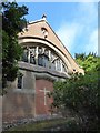
St Joseph's RC Church, West Lavington: mid August 2016
Image: © Basher Eyre
Taken: 22 Aug 2016
0.10 miles
7
![Path leaves the road [3]](https://s3.geograph.org.uk/geophotos/06/36/46/6364667_1583436b_120x120.jpg)
Path leaves the road [3]
From the road at the side of the Catholic church, the path apsses into woodland on its way to Littleton Panell.
West Lavington, along with Littleton Panell, form a nearly continuous line of ribbon development along the A360 Devizes to Salisbury road on the northern edge of Salisbury Plain. There is evidence of occupation in this area from late Neolithic or early Bronze Age times. The Dauntsey family owned land in the parish from at least 1474 and in 1542 William Dauntsey's bequest founded a school and almshouses.
Image: © Michael Dibb
Taken: 11 Sep 2019
0.10 miles
8

Entrance to Dauntsey's School
The School was founded in 1542, in accordance with the will of William Dauntesey, a master of the Worshipful Company of Mercers. It was moved to this present site in 1895.
Image: © Stuart Logan
Taken: 25 Apr 2013
0.11 miles
9
![West Lavington features [12]](https://s3.geograph.org.uk/geophotos/06/36/46/6364659_ab0f30c7_120x120.jpg)
West Lavington features [12]
The main gateway into Dauntsey's School.
West Lavington, along with Littleton Panell, form a nearly continuous line of ribbon development along the A360 Devizes to Salisbury road on the northern edge of Salisbury Plain. There is evidence of occupation in this area from late Neolithic or early Bronze Age times. The Dauntsey family owned land in the parish from at least 1474 and in 1542 William Dauntsey's bequest founded a school and almshouses.
Image: © Michael Dibb
Taken: 11 Sep 2019
0.12 miles
10
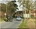
2009 : B3098 passing Dauntsey's School
Near Littleton Panell.
They had a very fine school orchestra at one time, probably still have. Anyone 'in the know?'
A quick search of WWW revealed http://www.dauntseys.wilts.sch.uk/page.aspx?id=1722
Image: © Maurice Pullin
Taken: 17 Mar 2009
0.12 miles