IMAGES TAKEN NEAR TO
Saxon Close, DEVIZES, SN10 4EF
Introduction
This page details the photographs taken nearby to Saxon Close, SN10 4EF by members of the Geograph project.
The Geograph project started in 2005 with the aim of publishing, organising and preserving representative images for every square kilometre of Great Britain, Ireland and the Isle of Man.

There are currently over 7.5m images from over14,400 individuals and you can help contribute to the project by visiting https://www.geograph.org.uk
Image Map
Images are licensed for reuse under creativecommons.org/licenses/by-sa/2.0
Notes
- Clicking on the map will re-center to the selected point.
- The higher the marker number, the further away the image location is from the centre of the postcode.
Image Listing (188 Images Found)
Images are licensed for reuse under creativecommons.org/licenses/by-sa/2.0
Image
Details
Distance
1
![Market Lavington buildings [10]](https://s0.geograph.org.uk/geophotos/06/56/69/6566904_52360de3_120x120.jpg)
Market Lavington buildings [10]
This 5 bay timber framed barn is dated 1820. Listed, for group value, grade II, with details at: https://historicengland.org.uk/listing/the-list/list-entry/1390687
Market Lavington lies at the foot of the north western scarp slope of Salisbury Plain, about 5 miles south of Devizes. There is evidence of continuous occupation of the village since the Iron Age and maybe, near continuous occupation since late Neolithic times. The village developed around the cross roads of an east-west road (now the B3098) and a north-south road which ran from Devizes to Salisbury – later closed. Once considered a town, a market charter was granted in 1254.
Image: © Michael Dibb
Taken: 19 May 2020
0.02 miles
2
![Market Lavington houses [22]](https://s0.geograph.org.uk/geophotos/06/56/68/6566896_7d807261_120x120.jpg)
Market Lavington houses [22]
The Old House, number 11 Parsonage Lane, is the only known aisled hall in the county. A manor house built in the 14th century, altered in the 16th century remodelled in the late 17th or early 18th century and restored in 1875. The house contains an early medieval double aisled open hall structure with contemporary cross wing of 2 bays within a rectangular plan of stone walls. Listed, grade I, with details at: https://historicengland.org.uk/listing/the-list/list-entry/1035851
Market Lavington lies at the foot of the north western scarp slope of Salisbury Plain, about 5 miles south of Devizes. There is evidence of continuous occupation of the village since the Iron Age and maybe, near continuous occupation since late Neolithic times. The village developed around the cross roads of an east-west road (now the B3098) and a north-south road which ran from Devizes to Salisbury – later closed. Once considered a town, a market charter was granted in 1254.
Image: © Michael Dibb
Taken: 19 May 2020
0.03 miles
3
![Market Lavington houses [23]](https://s1.geograph.org.uk/geophotos/06/56/78/6567889_8e5e6700_120x120.jpg)
Market Lavington houses [23]
Racquets Court, number 10 Parsonage Lane, was previously known as Fives Court. Built in the early 18th century as an outbuilding to the demolished Old Parsonage. Extended as a racquets court in the 1850s, raised to two storeys circa 1860, Listed, grade II, with details at: https://historicengland.org.uk/listing/the-list/list-entry/1364607
Market Lavington lies at the foot of the north western scarp slope of Salisbury Plain, about 5 miles south of Devizes. There is evidence of continuous occupation of the village since the Iron Age and maybe, near continuous occupation since late Neolithic times. The village developed around the cross roads of an east-west road (now the B3098) and a north-south road which ran from Devizes to Salisbury – later closed. Once considered a town, a market charter was granted in 1254.
Image: © Michael Dibb
Taken: 19 May 2020
0.05 miles
4
Part of the churchyard at St Mary's parish church, Market Lavington
Newer graves in this area.
Image: © Jeremy Bolwell
Taken: 30 Jul 2020
0.05 miles
5
![Russell Mill & Strawberry Hill Walk [5]](https://s2.geograph.org.uk/geophotos/03/99/80/3998026_d15d7d8c_120x120.jpg)
Russell Mill & Strawberry Hill Walk [5]
'This short path exits at Lower Grove Farm roundabout ....' See http://www.marketlavington.org.uk/Walks%204.html for more details.
Image: © Christine Johnstone
Taken: 25 May 2014
0.06 miles
6
![Russell Mill & Strawberry Hill Walk [6]](https://s0.geograph.org.uk/geophotos/03/99/80/3998032_fe99f4f0_120x120.jpg)
Russell Mill & Strawberry Hill Walk [6]
Lower Grove Farm roundabout, from Canada Rise.
Image: © Christine Johnstone
Taken: 25 May 2014
0.07 miles
7
![Parish church [4]](https://s3.geograph.org.uk/geophotos/06/56/87/6568719_aa748aae_120x120.jpg)
Parish church [4]
This fine mid 19th century, limestone, pedestal on plinth monument enclosed in railings is listed, grade II, with details at: https://historicengland.org.uk/listing/the-list/list-entry/1035838
The Anglican parish church of St Mary is late 13th century incorporating some earlier fabric. There were alterations and additions in the 14th and 15th centuries and the church was restored in circa 1860 and again in 1910. There are some fine wall monuments. Listed, grade I, with details at: https://historicengland.org.uk/listing/the-list/list-entry/1035835
Market Lavington lies at the foot of the north western scarp slope of Salisbury Plain, about 5 miles south of Devizes. There is evidence of continuous occupation of the village since the Iron Age and maybe, near continuous occupation since late Neolithic times. The village developed around the cross roads of an east-west road (now the B3098) and a north-south road which ran from Devizes to Salisbury – later closed. Once considered a town, a market charter was granted in 1254.
Image: © Michael Dibb
Taken: 19 May 2020
0.07 miles
8
![Market Lavington houses [21]](https://s1.geograph.org.uk/geophotos/06/56/68/6566881_d9e69c34_120x120.jpg)
Market Lavington houses [21]
The fine garden wall, gate piers and paving to The Old House, number 11 Parsonage Lane Image, are listed, grade II, with details at: https://historicengland.org.uk/listing/the-list/list-entry/1182789
Market Lavington lies at the foot of the north western scarp slope of Salisbury Plain, about 5 miles south of Devizes. There is evidence of continuous occupation of the village since the Iron Age and maybe, near continuous occupation since late Neolithic times. The village developed around the cross roads of an east-west road (now the B3098) and a north-south road which ran from Devizes to Salisbury – later closed. Once considered a town, a market charter was granted in 1254.
Image: © Michael Dibb
Taken: 19 May 2020
0.07 miles
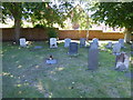
9
![Parish church [3]](https://s1.geograph.org.uk/geophotos/06/56/87/6568717_d84e7f09_120x120.jpg)
Parish church [3]
Part of the large graveyard which contains a number of listed monuments.
The Anglican parish church of St Mary is late 13th century incorporating some earlier fabric. There were alterations and additions in the 14th and 15th centuries and the church was restored in circa 1860 and again in 1910. There are some fine wall monuments. Listed, grade I, with details at: https://historicengland.org.uk/listing/the-list/list-entry/1035835
Market Lavington lies at the foot of the north western scarp slope of Salisbury Plain, about 5 miles south of Devizes. There is evidence of continuous occupation of the village since the Iron Age and maybe, near continuous occupation since late Neolithic times. The village developed around the cross roads of an east-west road (now the B3098) and a north-south road which ran from Devizes to Salisbury – later closed. Once considered a town, a market charter was granted in 1254.
Image: © Michael Dibb
Taken: 19 May 2020
0.07 miles
10

Part of Market Lavington Museum
Closed due to lockdown, but I must return.
Image: © Jeremy Bolwell
Taken: 30 Jul 2020
0.08 miles