IMAGES TAKEN NEAR TO
Rectory Lane, BANSTEAD, SM7 3PE
Introduction
This page details the photographs taken nearby to Rectory Lane, SM7 3PE by members of the Geograph project.
The Geograph project started in 2005 with the aim of publishing, organising and preserving representative images for every square kilometre of Great Britain, Ireland and the Isle of Man.

There are currently over 7.5m images from over14,400 individuals and you can help contribute to the project by visiting https://www.geograph.org.uk
Image Map (Loading...)


Getting Data...Please wait
Leaflet Map data © OpenStreetMap
Images are licensed for reuse under creativecommons.org/licenses/by-sa/2.0
Notes
- Clicking on the map will re-center to the selected point.
- The higher the marker number, the further away the image location is from the centre of the postcode.
Image Listing (18 Images Found)
Images are licensed for reuse under creativecommons.org/licenses/by-sa/2.0
Image
Details
Distance
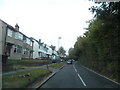
2
B278 Rectory Lane, Woodmansterne
Heading north.
Image: © Robin Webster
Taken: 18 Jan 2020
0.04 miles
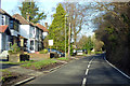
3
Houses on B278 Rectory Lane, Woodmansterne
Image: © Robin Webster
Taken: 18 Jan 2020
0.06 miles
4
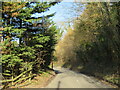
Rectory Lane, Woodmansterne, near Banstead
Rectory lane climbing out of Woodmansterne in Surrey. This road forms part of the route of the B278.
Image: © Malc McDonald
Taken: 19 Feb 2023
0.10 miles
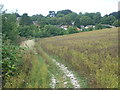
5
Path alongside Rectory Lane
This field is next to Rectory Lane and here is looking towards the outskirts of Woodmansterne.
Image: © Marathon
Taken: 14 Aug 2013
0.11 miles
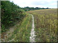
6
Path alongside Rectory Lane
This field is next to Rectory Lane and here is looking towards the outskirts of Woodmansterne. This is not an official footpath but is clearly well used.
Image: © Marathon
Taken: 14 Aug 2013
0.11 miles
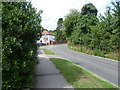
7
Rectory Lane, Woodmansterne
This is towards the outskirts of Woodmansterne. Manor Way is just ahead on the left.
Image: © Marathon
Taken: 14 Aug 2013
0.11 miles
8
Manor Way, Woodmansterne
Manor Way is a residential road in Woodmansterne, in Surrey.
Image: © Malc McDonald
Taken: 19 Feb 2023
0.14 miles
9
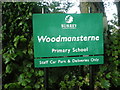
Woodmansterne Primary School sign
This was the photographer's first school, back in the mid fifties, when he lived on the Smallholdings. He had a walk of some 25 minutes there and back, in all weathers, including snow.
Image: © JOHN PARKIN
Taken: 11 Oct 2009
0.18 miles
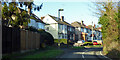
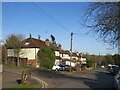
10
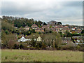
Housing, Woodmansterne
At the bottom are houses in Lakers Rise, further up the hill is The Readens, and beyond on the right, houses in Chipstead Way.
Image: © Robin Webster
Taken: 23 Nov 2010
0.21 miles