IMAGES TAKEN NEAR TO
Kingscroft Road, BANSTEAD, SM7 3LY
Introduction
This page details the photographs taken nearby to Kingscroft Road, SM7 3LY by members of the Geograph project.
The Geograph project started in 2005 with the aim of publishing, organising and preserving representative images for every square kilometre of Great Britain, Ireland and the Isle of Man.

There are currently over 7.5m images from over14,400 individuals and you can help contribute to the project by visiting https://www.geograph.org.uk
Image Map (Loading...)


Getting Data...Please wait
Leaflet Map data © OpenStreetMap
Images are licensed for reuse under creativecommons.org/licenses/by-sa/2.0
Notes
- Clicking on the map will re-center to the selected point.
- The higher the marker number, the further away the image location is from the centre of the postcode.
Image Listing (10 Images Found)
Images are licensed for reuse under creativecommons.org/licenses/by-sa/2.0
Image
Details
Distance
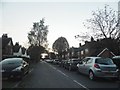
1
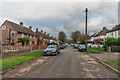
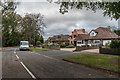
Kingscroft Road
Cul-de-sac off Chipstead Way, one group of houses near the start of which was marked on the 1913 1:2,500 map, much of rest on the 1935 edition and the final section on the 1958-9 edition (including the houses shown here).
Image: © Ian Capper
Taken: 27 Oct 2018
0.03 miles
2
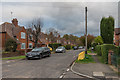
Kingscroft Road
Cul-de-sac off Chipstead Way, one group of houses near the start of which was marked on the 1913 1:2,500 map, much of rest on the 1935 edition (including the houses shown here), and the final section on the 1958-9 edition.
Image: © Ian Capper
Taken: 27 Oct 2018
0.07 miles
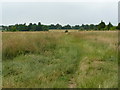
3
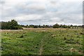
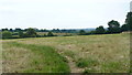
Off Kingscroft Road
Grassland off the end of Kingscroft Road.
Image: © Ian Capper
Taken: 27 Oct 2018
0.09 miles
5
Footpath Near Woodmansterne, Surrey
Looking in the direction of Banstead.
Image: © Peter Trimming
Taken: 4 Jul 2009
0.12 miles
6
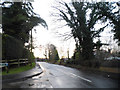
Woodmansterne Lane at the junction of Barn Close
This is the Surrey part of Woodmansterne, the other being in the London Borough of Croydon.
Image: © David Howard
Taken: 14 Jan 2013
0.12 miles
8
View Near Banstead, Surrey
Looking in the direction of Woodmansterne.
Image: © Peter Trimming
Taken: 4 Jul 2009
0.15 miles
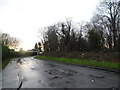
9
Cunningham Road
Road shown on the 1935 1:2,500 map in outline but without any development.
Image: © Ian Capper
Taken: 27 Oct 2018
0.19 miles