IMAGES TAKEN NEAR TO
Woodmansterne Lane, BANSTEAD, SM7 3HH
Introduction
This page details the photographs taken nearby to Woodmansterne Lane, SM7 3HH by members of the Geograph project.
The Geograph project started in 2005 with the aim of publishing, organising and preserving representative images for every square kilometre of Great Britain, Ireland and the Isle of Man.

There are currently over 7.5m images from over14,400 individuals and you can help contribute to the project by visiting https://www.geograph.org.uk
Image Map (Loading...)


Getting Data...Please wait
Leaflet Map data © OpenStreetMap
Images are licensed for reuse under creativecommons.org/licenses/by-sa/2.0
Notes
- Clicking on the map will re-center to the selected point.
- The higher the marker number, the further away the image location is from the centre of the postcode.
Image Listing (47 Images Found)
Images are licensed for reuse under creativecommons.org/licenses/by-sa/2.0
Image
Details
Distance
1
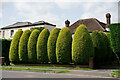
Banstead
Housing in Woodmansterne Lane.
Image: © Peter Trimming
Taken: 11 Aug 2021
0.02 miles
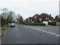
2

Woodmansterne Lane approaching Banstead
Image: © David Howard
Taken: 14 Jan 2013
0.06 miles
3
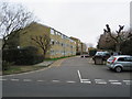
Well House, Banstead
Well House is a complex of privately-owned apartments in Banstead, in north Surrey.
Image: © Malc McDonald
Taken: 11 Jan 2020
0.09 miles
4
Longcroft Avenue, Banstead
Longcroft Avenue is a residential road in Banstead, in north Surrey.
Image: © Malc McDonald
Taken: 11 Jan 2020
0.10 miles
5
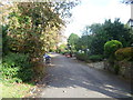
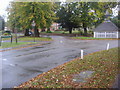
Croydon Lane South, Banstead
Croydon Lane South is a quiet residential road separated from the busy Croydon Lane (A2022) by some trees. It is a cul-de-sac at this western end so cannot be used to by-pass the roundabout.
Image: © Marathon
Taken: 4 Nov 2013
0.11 miles
6
Longcroft Avenue, Banstead
Longcroft Avenue is a tree-lined residential road in Banstead, in north Surrey.
This image was taken on a dull January day. Trees were bare for the winter season.
Image: © Malc McDonald
Taken: 11 Jan 2020
0.11 miles
7
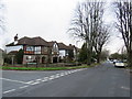
Woodmansterne Lane Banstead
At junction of Park Road
Image: © David Howard
Taken: 11 Oct 2009
0.11 miles
8

Croydon Lane South, Banstead
Croydon Lane South is a quiet residential road separated from the busy Croydon Lane (A2022) by some trees. It is a cul-de-sac at the western end so cannot be used to by-pass the roundabout.
Image: © Marathon
Taken: 4 Nov 2013
0.12 miles
9

Croydon Lane South, Banstead
Croydon Lane South is a quiet residential road separated from the busy Croydon Lane (A2022) by some trees. It is a cul-de-sac at the western end so cannot be used to by-pass the roundabout. The berries on the left were being caught by the sunlight.
Image: © Marathon
Taken: 4 Nov 2013
0.12 miles
10
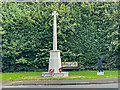
Banstead War Memorial
War memorial unveiled 5 June 1921. Grade II listed - see https://historicengland.org.uk/listing/the-list/list-entry/1458546?section=official-list-entry.
Image: © Ian Capper
Taken: 7 Oct 2022
0.12 miles